Small and medium-sized avalanches will occur during snowfall, especially on very steep slopes. South-westerly winds will produce snow drifts that can be overloaded with a light load and trigger a medium avalanche.
Snowpack
The old snow cover over the forest fringe was heavily redistributed by the north-easterly wind, with large areas blown down to bare ground. Snow drifts have formed, particularly on the southern sides of the ridges. So far, only a few centimetres of fresh snow have fallen on such a surface.
Snow is falling in the high mountains with a strong south-westerly wind. Initially, the snowline will be above 1400-1600 m, and above 1700-1800 m on Tuesday night. In the intermediate altitude band, 10-20 cm of snow will fall by Monday evening, with a warming and rain on the way. Above 1800 m, more than 40 cm of snow will fall by Tuesday afternoon. Between 1400 and 1800 m, the snow cover will thicken slightly less due to rain with a transient warming.
Tendency
It will be cooler during the day on Tuesday, with a northeasterly breeze overnight on Wednesday. In cold weather, the snow cover will slowly stabilise. In the high mountains, where snow will fall throughout Monday and Tuesday, north-easterly winds will bring snow on Wednesday, building drifts on the mainly southern sides of the ridges. The risk of avalanches will therefore also occur in places that will be more stable on Tuesday. Below about 1800 m, the amount of snow for wind transport will be limited due to transient rain and crust formation.
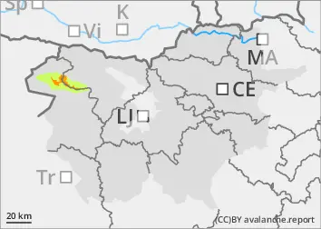
Danger level
1800m
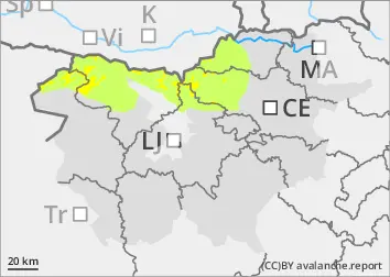
Avalanche Problem
New snow
1800m
Wind slab
1800m
Persistent weak layer
2400m
Some new snow in the high mountains
Small and medium-sized avalanches will occur during snowfall, especially on very steep slopes. South-westerly winds will produce snow drifts that can be overloaded with a light load and trigger a medium avalanche.
Snowpack
The old snow cover over the forest fringe was heavily redistributed by the north-easterly wind, with large areas blown down to bare ground. Snow drifts have formed, particularly on the southern sides of the ridges. On the highest peaks (above 2400 m) the snow cover is thicker and contains weak layers. So far, a few centimetres of fresh snow have fallen on such a surface.
In the high mountains, snow is falling with a strong south-westerly wind. Initially, the snowline will be above 1400-1600 m, and above 1700-1800 m on Tuesday night. In the intermediate altitude band, 10-20 cm of snow will fall by Monday evening, with a warming and rain on the way. Above 1800 m, more than 20 cm of snow will fall by Tuesday afternoon. Between 1400 and 1800 m, the snow cover will thicken slightly less as a result of rain and a transient warming.
Tendency
It will cool down during the day on Tuesday, with a northeasterly breeze overnight on Wednesday. In cold weather, the snow cover will slowly stabilise. In the high mountains, where snow will fall throughout Monday and Tuesday, north-easterly winds will bring snow on Wednesday, building drifts on the mainly southern sides of the ridges. The risk of avalanches will therefore also occur in places that will be more stable on Tuesday. Below about 1800 m, the amount of snow for wind-driven transport will be limited due to transient rain and crust formation.