There are areas of blowing snow, with snow showers during the day.
Ridges and peaks are in many places blown down. Areas of blown snow are present, especially on south-west facing slopes. When snow drifts on steep slopes are loaded, they can trigger avalanches of dry snow. A strong to moderate south-westerly wind is blowing, transporting snow to the leeward side of the ridges. On the steepest slopes, a small avalanche of new snow may be triggered.
Snowpack
During the last deterioration, almost one metre of new snow fell above about 2400 m. Especially in the vicinity of the ridges, drifts have formed. About 10 cm of new snow will fall on the existing snow base over the course of the day above an altitude of about 1500 m, with lower snowfall limits in leeward areas. The snow will be accompanied by strong south-westerly winds, which will build up new drifts. Weak layers may be hidden in the old snow cover.
Tendency
On Tuesday, it will snow and the risk of avalanches will increase.
Danger level
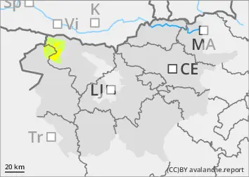
1600m
Avalanche Problem
Wind slab
1600m
New snow
1500m
There are areas of blowing snow, with snow showers during the day.
Ridges and peaks are in many places blown down. Areas of blown snow are present, especially on south-west facing slopes. When snow drifts on steep slopes are loaded, they can trigger avalanches of dry snow. A strong to moderate south-westerly wind is blowing, transporting snow to the leeward side of the ridges. On the steepest slopes, a small avalanche of new snow may be triggered.
Snowpack
Especially near the ridges, there is a lot of drifting, and little old snow. Up to 20 cm of new snow will fall on the existing snow base during the day above an altitude of about 1500 m, with lower snowfall limits in leeward areas. The snow will be accompanied by strong south-westerly winds, which will build up new drifts. The old snow cover may hide layers of Indian wheat, which are a weak layer.
Tendency
On Tuesday, it will snow and the risk of avalanches will increase.
Danger level
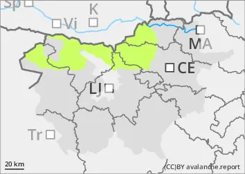
1500m
Avalanche Problem
New snow
1500m
Wet snow
1500m
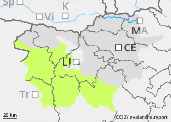
The snowline is high.
In some places, there may be small areas of blowing snow. Small avalanches are possible on the steepest slopes.
Snowpack
Snowfall in the mountains is low, up to 30 cm at the highest points. Small snow drifts may occur close to the ridges. During the day, the snowline rises to around 1500 m. Below this height, it will rain and the rain will wet the snow base.