Daytime increase of avalanche danger. Beware snowdrifts in high-alpine zones.
Avalanche danger is initially low, then rises during the afternoon above 1600m to moderate. On steep slopes below 2600m which have not yet discharged, medium-sized wet-snow avalanches can trigger naturally or be triggered by persons. Also isolated small-to-medium glide-snow avalanches are possible. In high-alpine zones, fresh snowdrift accumulations require attentiveness, most of them are small but often easily triggered. Danger zones occur in gullies, bowls, behind protruberances in the terrain and on steep shady slopes above 2600m. Isolated small-to-medium avalanches can be triggered by winter sports enthusiasts in the old snow. Avalanche prone locations lie in seldom-tracked shady terrain and are difficult to recognize.
Snowpack
During nights of clear skies, little wind and dry air, the snowpack can consolidate superficially and in many places form a melt-freeze crust capable of bearing loads. Through higher daytime temperatures and solar radiation, the crust then softens rapidly and the snowpack loses its firmness. Beneath the melt-freeze crust the snowpack is thoroughly wet up to high altitudes. At high altitudes there is up to 15cm of fresh snow lying deposited atop the moist old snowpack surface. On south-facing slopes the fresh snow fell on bare ground at intermediate altitudes. In the foehn lanes, fresh trigger-sensitive snowdrift accumulations can be generated, deposited esp. in high-alpine zones ato soft layers on steep shady slopes and thus, prone to triggering. On very steep shady slopes at high altitudes, unfavorable intermediate layers are often evident inside the old snowpack, particularly in the Silvretta region.
Tendency
Easter Sunday will be quite sunny. Avalanche danger will be increasingly determined by the daytime danger cycle.
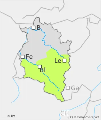
BEFORE NOON Danger level
1600m
Avalanche Problem
Gliding snow
1600m
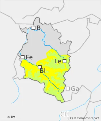
AFTERNOON Danger level
1600m
Avalanche Problem
Wet snow
1600m
Gliding snow
1600m
Caution: daytime cycle of avalanche danger
Avalanche danger in the morning hours is low, rises during the afternoon hours to moderate above 1600m. On steep slopes in all aspects which have not yet discharged, wet-snow avalanches can release naturally or be triggered by winter sports enthusiasts and, in high altitude zones, grow to medium size. In isolated cases small-to-medium glide-snow avalanches are possible.
Snowpack
During a night of clear skies, little wind and dry air, the snowpack can consolidate superficially and in many places form a melt-freeze crust capable of bearing loads. Through higher daytime temperatures and solar radiation, the crust then softens rapidly and the snowpack loses its firmness. Beneath the melt-freeze crust the snowpack is thoroughly wet up to high altitudes. At high altitudes there is up to 15cm of fresh snow lying deposited atop the moist old snowpack surface. On south-facing slopes the fresh snow fell on bare ground at intermediate altitudes. In the foehn lanes, fresh trigger-sensitive snowdrift accumulations can be generated, deposited esp. in high-alpine zones ato soft layers on steep shady slopes and thus, prone to triggering.
Tendency
Easter Sunday will be quite sunny. Avalanche danger will be increasingly determined by the daytime danger cycle.
Danger level
Avalanche Problem
Wet snow
Isolated wet-snow and glide-snow avalanches
Avalanche danger is low. Wet-snow and glide-snow avalanches can trigger naturally during the course of the day , esp. on steep north-facing slopes, these can also be triggered by persons in steep terrain. The releases are mostly small-sized. Apart from the danger of being buried in snow masses, the risks of being swept along and forced to take a fall require adequate caution.
Snowpack
During a night of clear skies, little wind and dry air, the snowpack can consolidate superficially and in many places form a melt-freeze crust capable of bearing loads. Through higher daytime temperatures and solar radiation, the crust then softens rapidly and the snowpack loses its firmness. Beneath the melt-freeze crust the snowpack is thoroughly wet up to high altitudes.
Tendency
Easter Sunday will be quite sunny. Avalanche danger will be increasingly determined by the daytime danger cycle.