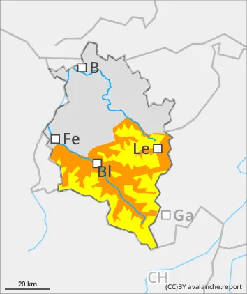
Main danger: wet-snow avalanches. Beware fresh snowdrifts in high-alpine zones.
Avalanche danger below 2800m is considerable, above that altitude danger is moderate. On steep slopes in all aspects which have not yet discharged, wet-snow and glide-snow avalanches can trigger naturally and grow to medium-to-large size. In high-alpine zones, fresh snowdrift accumulations require attentiveness, they are usually small, but often easily triggered. Danger zones occur in gullies, bowls, behind protruberances in the terrain and on very steep shady slopes above 2800m. In addition, winter sports enthusiasts can trigger small-to-medium avalanches in the old snow in isolated cases. Danger zones occur in little-tracked backcountry terrain, mostly on very steep NW/N/NE-facing slopes and are difficult to recognize.
Snowpack
On Thursday, minor snowfall above 2000m. Moist/warm air masses and rainfall will make the snowpack forfeit its firmness. During the night, up to 5cm of fresh snow is anticipated above 1500m. On Good Friday temperatures will drop, a bit of fresh snow is expected. Danger of wet-snow avalanches will recede. Due to strong SE/SW winds, small snowdrifts accumulated on Wednesday night, particularly in high-alpine zones they were deposited on very steep shady slopes atop soft layers and are often prone to triggering. These will consolidated increasingly. On south-facing slopes up to high altitudes, hardly any snow on the ground. Also on shady slopes, intermediate altitudes are increasingly bare of snow. On very steep shady slopes at high altitudes, often unfavorable intermediate layers are evident inside the old snowpack, particularly in the Silvretta.
Tendency
On the weekend, often sunny and mild. Avalanche danger levels will recede further and be subject to a daytime danger cycle.
Danger level
1600m
Avalanche Problem
Wet snow
1600m
Gliding snow
1600m
Isolated wet-snow and glide-snow avalanches
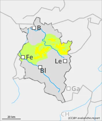
Avalanche danger below 1600m is moderate. On steep slopes in all aspects which have not yet discharged, wet-snow and glide-snow avalanches can trigger naturally and grow to medium-to-large size. In high-alpine zones, fresh snowdrift accumulations require attentiveness, they are usually small, but often easily triggered, need to be assessed with caution.
Snowpack
On Thursday, minor snowfall above 2000m. Moist/warm air masses and rainfall will make the snowpack forfeit its firmness. During the night, up to 5cm of fresh snow is anticipated above 1500m. On Good Friday temperatures will drop, a bit of fresh snow is expected. Danger of wet-snow avalanches will recede. Due to strong SE/SW winds, small snowdrifts accumulated on Wednesday night, particularly in high-alpine zones they were deposited on very steep shady slopes atop soft layers and are often prone to triggering. These will consolidated increasingly. On south-facing slopes up to high altitudes, hardly any snow on the ground. Also on shady slopes, intermediate altitudes are increasingly bare of snow. On very steep shady slopes at high altitudes, often unfavorable intermediate layers are evident inside the old snowpack.
Tendency
On the weekend, often sunny and mild. Avalanche danger levels will recede further and be subject to a daytime danger cycle.
Danger level
Avalanche Problem
Wet snow
Isolated wet-snow and glide-snow avalanches
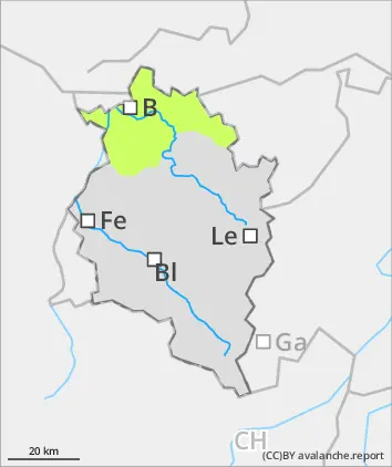
Avalanche danger is low. On steep north-facing slopes, wet-snow and glide-snow avalanches can increase naturally. Wet-snow avalanches can be triggered by persons in steep terrain, mostly small releases. Apart from the danger of being buried in snow masses, the risks of being swept along and forced to take a fall require adequate caution.
Snowpack
On Thursday, minor snowfall above 2000m. Moist/warm air masses and rainfall will make the snowpack forfeit its firmness. During the night, up to 5cm of fresh snow is anticipated above 1500m. On Good Friday temperatures will drop, a bit of fresh snow is expected. Danger of wet-snow avalanches will recede. On south-facing slopes up to high altitudes, hardly any snow on the ground. Also on shady slopes, intermediate altitudes are increasingly bare of snow. On very steep shady slopes at high altitudes, often unfavorable intermediate layers are evident inside the old snowpack.
Tendency
On the weekend, often sunny and mild. Avalanche danger levels will recede further and be subject to a daytime danger cycle.