Naturally triggered wet-snow avalanches will recede as precipitation ends
Naturally triggered wet-snow avalanches will recede as precipitation ends and temperatures drop. Wet-snow avalanches can still be triggered by winter sports enthusiasts, esp. on very steep slopes in all aspects at high altitudes. Avalanches can fracture down lower and sweep along the entire wet snowpack, thus grow to medium size.
Snowpack
dp.3: rain dp.10: springtime scenario
Weather conditions are making the snowpack ever wetter, leading to a loss of firmness inside the snowpack, resulting to loss of snowpack firmness. Many starting zones have already completely dishcharged. On steep sunny slopes below 1600m, hardly any snow on the ground.
Tendency
Beware wet snow
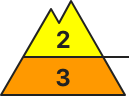
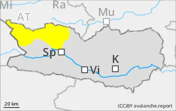
BEFORE NOON Danger level
2800m
Avalanche Problem
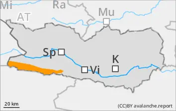
Wet snow
2800m
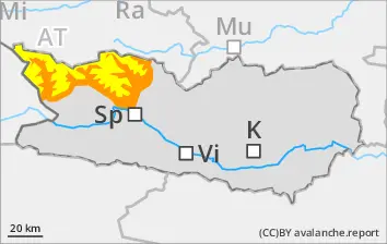
Wind slab
2800m
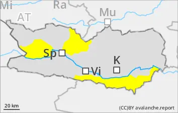
AFTERNOON Danger level
2800m
Avalanche Problem
Wet snow
2800m
Wind slab
2800m
Due to rainfall, wet-snow avalanches possible at any time or day or night. Fresh snowdrifts in high-alpine zones.
Naturally triggered wet-snow avalanches will recede as precipitation ends and temperatures drop. Wet-snow avalanches can still be triggered by winter sports enthusiasts, esp. on very steep slopes in all aspects below 2800m. Avalanches can fracture down lower and sweep along the entire wet snowpack, thus grow to medium size. Fresh snowdrift accumulations can be triggered by one sole skier on very steep shady slopes above 2800m. Such danger zones occur esp. in ridgeline terrain, in gullies and in bowls.
Snowpack
dp.10: springtime scenario dp.6: cold, loose snow and wind
Weather conditions below 2800m are leading to the snowpack becoming thoroughly wet. Many wet-snow avalanches have already released, many starting zones have completely discharged, the snowpack is thoroughly wet. High-alpine zones: up to 20cm of fresh snowfall expected, locally more. Due to fresh fallen snow and often strong southerly winds, small new snowdrift accumulations will be generated. On steep sunny slopes below 1900m there is hardly any snow on the ground.
Tendency
Beware wet snow and fresh snowdrifts
BEFORE NOON Danger level
Avalanche Problem
Wet snow
AFTERNOON Danger level
Avalanche Problem
Wet snow
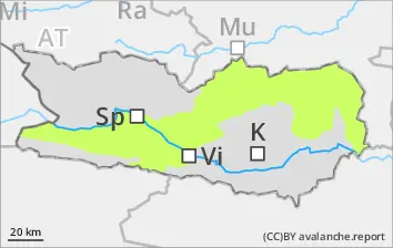
Naturally triggered wet-snow avalanches will recede as precipitation ends
Naturally triggered wet-snow avalanches will recede as precipitation ends and temperatures drop. Wet-snow avalanches can still be triggered by winter sports enthusiasts, esp. on very steep slopes in all aspects at high altitudes.
Snowpack
dp.3: rain dp.10: springtime scenario
Weather conditions are leading to the snowpack becoming thoroughly wet. Many wet-snow avalanches have already released, many starting zones have completely discharged, the snowpack is thoroughly wet. On steep sunny slopes and below 1800m there is hardly any snow on the ground.
Tendency
Beware wet snow
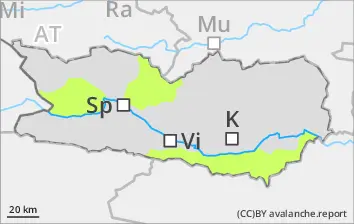
Danger level
Avalanche Problem
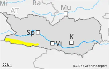
Wet snow
Isolated danger zones
Only naturally triggered wet-snow slides will recede as precipitation ends and temperatures drop, esp by large additional loading. Such danger zones occur on very steep slopes at high altitudes.
Snowpack
dp.3: rain dp.10: springtime scenario
Weather conditions are leading to the snowpack becoming thoroughly wet. Many wet-snow avalanches have already released, many starting zones have completely discharged, the snowpack is thoroughly wet. On steep sunny slopes and below 1800m there is hardly any snow on the ground.