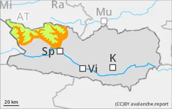
Due to moist air, danger of wet-snow avalanches increases significantly to Danger Level 3 - Considerable - during the course of the day. Wet slab avalanches are possible, esp. at the foot of rock walls along the Italian border. Wet-snow avalanches can fracture down to ground level and grow to medium size, esp. in regions where snowfall has been heavier. Runout zones should be avoided.
Snowpack
Following a night of overcast skies, reduced outgoing radiation and the snowpack surface can freeze only superficially, it softens swiftly in the morning. Weather conditions are making the snowpack ever wetter.
Tendency
Due to rainfall, likelihood of wet-snow avalanches triggering is on the increase
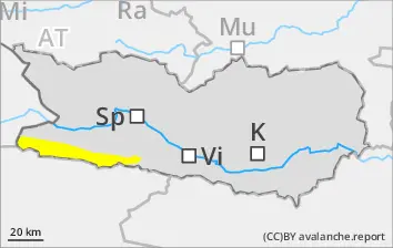
BEFORE NOON Danger level
2600m
Avalanche Problem
Wet snow
2600m
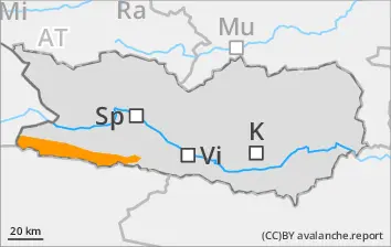
AFTERNOON Danger level
2600m
Avalanche Problem
Wet snow
2600m
Increasing danger of wet-snow avalanches
Due to moist air, danger of wet-snow avalanches increases significantly to Danger Level 3 - Considerable - during the course of the day. Wet slab avalanches are possible, esp. at the foot of rock walls along the Italian border. Wet-snow avalanches can fracture down to ground level and grow to medium size, esp. in regions where snowfall has been heavier. Runout zones should be avoided.
Snowpack
dp.10: springtime scenario
Following a night of overcast skies, reduced outgoing radiation and the snowpack surface can freeze only superficially, it softens swiftly in the morning. Weather conditions are making the snowpack ever wetter.
Tendency
Due to high air moisture, likelihood of wet-snow avalanches triggering is on the increase
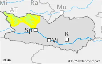
BEFORE NOON Danger level
Avalanche Problem
Wet snow
AFTERNOON Danger level
Avalanche Problem
Wet snow
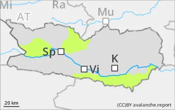
Due to air moisture, danger of wet-snow avalanches rises significantly during the course of the day - to Danger Level 2, Moderate. Wet slab avalanches are possible. Wet-snow avalanches can fracture down to ground level and thus grow to medium size. Runout zones should be avoided.
Snowpack
dp.10: springtime scenario
Overcast skies during the nightttime hours, outgoing longwave radiation is much reduced. The snowpack can freeze only superficially and softens rapidly in early morning. Weather conditions are making the snowpack ever wetter.
Tendency
Due to rainfall, likelihood of wet-snow avalanches triggering is on the increase
Danger level
Avalanche Problem
Wet snow
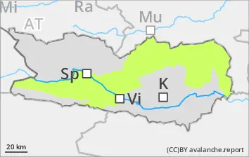
Likelihood of wet-snow slides will rise during daytime hours
Due to daytime warming and solar radiation, likelihood of wet snow slides will increase during the course of the day. Runout zones should be avoided. Some starting zones have already completely discharged. On hardened surfaces, acute danger of falls, esp. in the morning hours.
Snowpack
dp.10: springtime scenario
Nocturnal outgoing longwave radiation will be quite good. The snowpack surface will freeze and be capable of bearing loads in early morning, softening subsequently over the course of the day. As of midday, sunshine and warmth will make the snowpack increasingly wet. Below 1600m there is hardly any snow on the ground.