Due to NW winds, trigger-sensitive snowdrifts are accumulating at high altitudes. Also the near-surface weak layers are prone to triggering in steep shady little-tracked terrain. One sole skier can trigger and small-to-medium sized slab avalanche in these zones. Wind-loaded steep terrain should be evaluated with caution. Small, in isolated cases medium-sized glide-snow avalanches are still possible. Due to daytime warming and solar radiatio, increasingly frequent loose-snow avalanches can trigger naturally on sunny slopes in steep rocky terrain.
Snowpack
Since yesterday, up to 20cm of fresh snow has been registered widespread, in the Lechquellen 30cm, in Rätikon and Silvretta 25cm. The snowdrifts which were generated by northerly winds have been deposited atop soft layers and are prone to triggering. On shady slopes at high and high alpine altitudes the near-surface and often faceted intermediate layers are prone to triggering. The snowpack is thoroughly wet up to high altitudes. Gliding movements over smooth ground continue to be possible.
Tendency
On Monday, frequent and persistent snowfall, large amounts of fresh fallen snow are expected. Avalanche danger levels will continue to rise due to fresh snowdrifts at high altitudes.
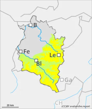
Danger level
treeline
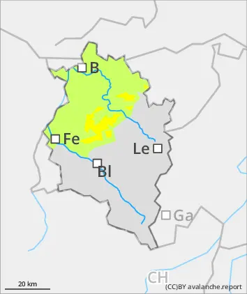
Avalanche Problem
Wind slab
Treeline
Circumvent fresh snowdrifts
Due to NW winds, trigger-sensitive snowdrifts are accumulating at high altitudes. Also the near-surface weak layers are prone to triggering in steep shady little-tracked terrain. One sole skier can trigger and small-to-medium sized slab avalanche in these zones. Wind-loaded steep terrain should be evaluated with caution. Small, in isolated cases medium-sized glide-snow avalanches are still possible. Due to daytime warming and solar radiatio, increasingly frequent loose-snow avalanches can trigger naturally on sunny slopes in steep rocky terrain.
Snowpack
Since yesterday there has been 20cm of fresh snow registered. Winds from northerly directions have generated fresh snowdrift accumulations which were deposited atop soft layers and are prone to triggering. The snowpack is thoroughly wet up to high altitudes. Gliding movements of the snow masse over smooth ground are still possible.
Tendency
On Monday, frequent and persistent snowfall, large amounts of fresh fallen snow are expected. Avalanche danger levels will continue to rise due to fresh snowdrifts at high altitudes