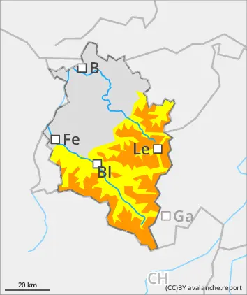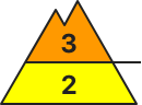
Danger level
 | 1500m |
|  |
|  |

![]()
Attention: fresh snow and snowdrifts prone to triggering
The fresh fallen snow will be transported by brisk-to-strong northerly winds, further snowdrifts will accumulate. Isolated avalanches can be triggered by winter sports enthusiasts, mostly medium-sized releases. Danger zones are often blanketed, difficult to recognize. Whumpf noises and glide cracks when you tread upon the snowpack surface are indicators of possible danger. Also naturally triggered avalanches are possible. Small-to-medium glide-snow avalanches are still possible.
Snowpack
Since Friday night, 20-30cm of fresh snow has been registered, locally more. Last night the peaks were shrouded in fog, a crust formed on the snowpack surface which was not capable of bearing loads. The fresh snow and fresh snowdrifts from northerly winds often lie deposited atop soft layers and are prone to triggering. During the nighttime hours and in early morning, another 10-20cm of fresh snow is anticipated, in Bregenzerwald up to 40cm, which will be transported by brisk-to-strong N/NW winds. The old snowpack is thoroughly wet up to high altitudes. The weight of the fresh fallen snow enhances gliding movements over smooth ground.
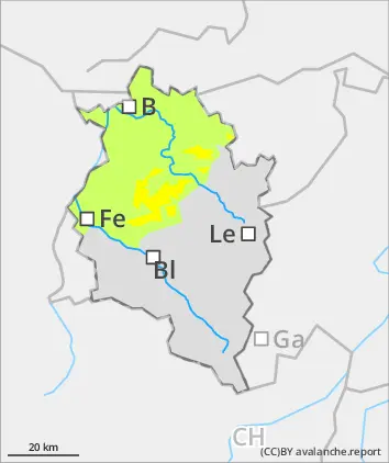
Tendency
On Tuesday, sunshine will prevail amid brisk-to-strong easterly winds. Avalanche danger levels are not expected to change significantly.