Caution: trigger-sensitive fresh snow at high altitudes. Receding danger of wet avalanches due to reduced precipitation.
From zones which have not yet discharged, further wet loose-snow avalanches can be expected, also medium-sized releases. In addition, isolated small-to-medium wet slab avalanches are possible at the foot of rock walls. Runout zones of wet-snow avalanches should be avoided. Naturally triggered wet-snow avalanches will decrease as rainfall comes to an end. Above 1700m, fresh fallen snow and drifts are prone to triggering, one sole skier can trigger avalanches esp. in gullies and bowls in the zones which are much wind-impacted. Avalanches can in isolated cases fracture down to more deeply embedded layers of the snowpack and then lengtrhen the runout zones. Due to solar radiation, increasingly frequent loose-snow avalanches can be expected during the course of the day, mostly small-sized releases in case of extensive bright intervals.
Naturally triggered small-to-medium wet avalanches will increase as rainfall sets in. On extremely steep slopes, small-to-medium wet loose-snow avalanches can be expected. Particularly at the foot of rock walls, small-to-medium wet slab avalanches are possible. Runout zones of wet-snow avalanches should be avoided. Above 1900m: lots of fresh snow expected which will be prone to triggering, also the freshly generated snowdrift accumulations, esp. in gullies and bowls in zones with wind impact. Avalanches can in isolated cases sweep along the thoroughly wet snowpack, which then lengthens the runout zone of the plummeting snow masses.
Snowpack
dp.3: rain dp.4: cold following warm / warm following cold
Rainfall will make the snowpack thoroughly wet, esp. below 1700m. Above 1700m, 30-40cm of fresh snow has been registered. By morning, another 10-20cm is expected. The fresh fallen snow is prone to triggering. In the lowermost part of the snowpack on N/W/E-facing slopes, faceted expansively metamorphosed weak layers threaten.
Tendency
Unchanged avalanche danger levels
Danger level
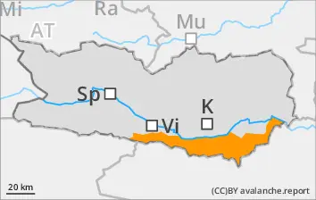
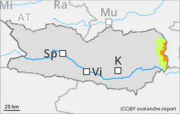
2200m
Avalanche Problem
Persistent weak layer
2200m
Wind slab
2300m
Avoid fresh snowdrifts. Starting at midday, CONSIDERABLE danger level.
Fresh snowfall and strong-to-stormy northerly winds generated new snowdrift accumulations esp. in gullies and bowls, behind protruberances in the terrain which can be triggered in the old snow and reach medium size, particularly in wind-protected zones. Even one sole skier can trigger avalanches. Danger zones occur esp. on W/N/E-facing slopes above 2300m. Very isolated danger zones occur also on south-facing slopes above 2600m. In isolated cases, avalanches can sweep along more deeply embedded layers of the snowpack. Danger zones and likelihood of triggering will increase during the course of the day. In addition, avalanches can trigger in the near-surface layers even by one sole skier, esp. in the afternoon in the wind-impacted zones.
Snowpack
dp.6: cold, loose snow and wind
Along the Salzburg border, 20-30cm of fresh snow was registered, by morning another 10-15cm is anticipated. The often storm-strength winds will transport the snow, the freshly generated snowdrift accumulations above 2200m will be deposited atop an unfavorable old snowpack surface. Inside the old snowpack on N/W/E-facing slopes, faceted expansively metamorphosed weak layers threaten. The fresh drifts above 2300m lie deposited atop weak layers.
Tendency
Rising avalanche danger
Danger level
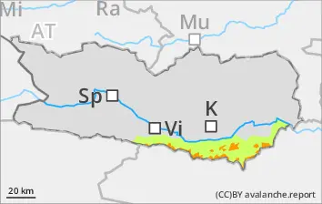
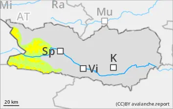
1800m
Avalanche Problem
Wind slab
1800m
Avalanche situation demands great caution
Fresh snowfall and strong-to-stormy northerly winds have generated trigger-sensitive snowdrift accumulations esp. in gullies, bowls, behind protruberances in the terrain, which can easily be triggered in all aspects above 1800m or else trigger naturally. Danger zones are easily recognized for the practiced eye. Due to solar radiation, increasingly frequent loose-snow avalanches can be expected during the course of the day, mostly small-sized releases.
Snowpack
dp.6: cold, loose snow and wind dp.4: cold following warm / warm following cold
Until now, 40-50cm of fresh snow has been registered above 1800m. By morning, another 10-20cm is expected. The freshly generated snowdrift accumulations lie atop unfavorable layers in all aspects above 1800m
Tendency
Avalanche danger levels will recede
Danger level
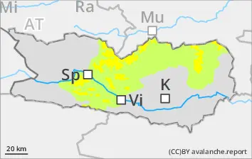
2000m
Avalanche Problem
Persistent weak layer
2000m
Wind slab
2200m
Beware fresh snowdrifts
Fresh snowfall and strong-to-stormy northerly winds will generate new snowdrift accumulations esp. in gullies and bowls, behind protruberances in the terrain which can be triggered in the old snow and reach medium size, particularly in wind-protected zones. Even one sole skier can trigger avalanches. Danger zones occur esp. on W/N/E-facing slopes above 2200m. Very isolated danger zones occur also on south-facing slopes above 2600m. In isolated cases, avalanches can sweep along more deeply embedded layers of the snowpack. Danger zones and likelihood of triggering will increase during the course of the day. In addition, avalanches can trigger in the near-surface layers even by one sole skier, esp. in the afternoon in the wind-impacted zones.
Snowpack
dp.6: cold, loose snow and wind
Above 2000m, 5-10cm of fresh snow anticipated which will be transported by stormy winds. The fresh snowdrifts above 2200m will be deposited atop an unfavorable snowpack. In the uppermost part of the snowpack on N/W/E facing slopes, faceted expansively metamorphosed weak layers threaten.
Tendency
Little change expected
Danger level
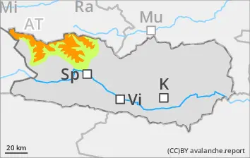
1900m
Avalanche Problem
Wind slab
1900m
Avoid snowdrift accumulations
Fresh snowfall and strong-to-stormy northerly winds will generate new snowdrift accumulations esp. in gullies and bowls, behind protruberances in the terrain which can be triggered in the old snow and reach medium size, particularly in wind-protected zones. Even one sole skier can trigger avalanches. Danger zones occur esp. on W/N/E-facing slopes above 2200m. Very isolated danger zones occur also on south-facing slopes above 2600m. In isolated cases, avalanches can sweep along more deeply embedded layers of the snowpack. Danger zones and likelihood of triggering will increase during the course of the day.
Snowpack
dp.6: cold, loose snow and wind
Above 1800m, 20-30cm of fresh snow anticipated, by morning another 10-15cm of fresh fallen snow. Strong winds will transport the snow, fresh snowdrift accumulations will be deposited atop an unfavorable surface above 1900m.