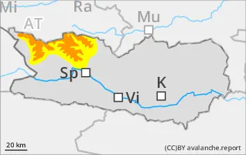
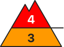
Avoid fresh snowdrifts. Starting at midday, CONSIDERABLE danger level.
Fresh snowfall and strong-to-stormy northerly winds generated new snowdrift accumulations esp. in gullies and bowls, behind protruberances in the terrain which can be triggered in the old snow and reach medium size, particularly in wind-protected zones. Even one sole skier can trigger avalanches. Danger zones occur esp. on W/N/E-facing slopes above 2300m. Very isolated danger zones occur also on south-facing slopes above 2600m. In isolated cases, avalanches can sweep along more deeply embedded layers of the snowpack. Danger zones and likelihood of triggering will increase during the course of the day. In addition, avalanches can trigger in the near-surface layers even by one sole skier, esp. in the afternoon in the wind-impacted zones.
Snowpack
dp.6: cold, loose snow and wind
Since Saturday, 20-40cm of fresh snow has been registered along the Salzburg border. By afternoon, 20-30cm is still anticipated, locally more. Often stormy winds will intensively transport the fresh fallen snow. The freshly generated snowdrifts lie deposited in all aspects above 2200m atop soft layers. On N/W/E-facing slopes, trigger-sensitive weak layers are evident. The new snowdrift accumulations lie deposited atop soft layers above 2200m.
Due to fresh fallen snow and strong-to-stormy northerly winds, further snowdrift accumulations are being generated esp. in gullies, bowls and behind protruberances in the terrain. Avalanches can be triggered in the weak old snow by one sole skier. Danger zones occur esp. on W/N/E-facing slopes above 2200m. Isolated danger zones also lie on south-facing slopes above 2600m. Avalanches can also be triggered in the near-surface layers of the snowpack in all aspects above 2200m. The releases can fracture down to deeper layers and thereby grow to medium size. Due to snowfall, increasingly frequent loose-snow avalanches can be expected, mostly small releases.
Snowpack
dp.6: cold, loose snow and wind dp.1: deep persistent weak layer
Since Saturday, 5-10cm of fresh snow has been registered above 2200m, by afternoon another 10-15cm is anticipated. The often storm strength winds will transport the fresh snow intensively. The snowdrifts will be deposited atop a weak old snowpack above 2200m. Inside the old snowpack on N/W/E-facing slopes there are faceted, expansively metamorphosed weak layers. The fresh snowdrifts lie deposited atop soft layers above 2200m.
Tendency
No significant change expected
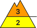
Danger level
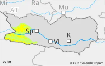
2200m
Avalanche Problem
Persistent weak layer
2200m
New snow
2000m
Main danger: fresh snow and persistent weak layers
The large amounts of fresh fallen snow and widespread snowdrift accumulations can easily be triggered above 2200m or else trigger naturally. Avalanches can fracture to lower layers and sweep them away, thereby grow to large size, esp. on steep, little-tracked shady slopes above 2200m and on steep, little-tracked W/E-facing slopes above 2600m. Remote triggerings and natural triggerings can be expected.
In addition, glide-snow avalanches can be expected at any time of day or night, particularly on grass-covered slopes below 2400m in zones where precipitation has been heavy.
Snowpack
dp.6: cold, loose snow and wind
Since Saturday, 30-50cm of fresh snow has been registered, esp. at high and high-alpine altitudes. By Tuesday, 50-70cm is still anticipated, locally more. The fresh snow and freshly generated snowddrifts lie deposited in all aspects above 2000m atop soft layers. On W/S/E-facing slopes below 2400m, the fresh fallen snow lies atop a crust. Inside the old snowpack, particularly on little-tracked W/N/E-facing slopes, trigger-sensitive weak layers are evident, esp. on shady slopes above 2200m and on W/E facing slopes above 2600m.
Tendency
Gradually receding avalanche danger
Danger level
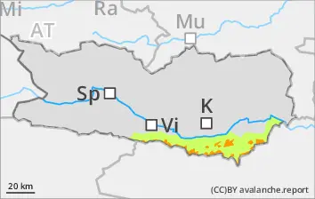
2000m
Avalanche Problem
Persistent weak layer
2000m
Wind slab
2200m
Beware fresh snowdrifts
Fresh snowfall and strong-to-stormy northerly winds will generate new snowdrift accumulations esp. in gullies and bowls, behind protruberances in the terrain which can be triggered in the old snow and reach medium size, particularly in wind-protected zones. Even one sole skier can trigger avalanches. Danger zones occur esp. on W/N/E-facing slopes above 2200m. Very isolated danger zones occur also on south-facing slopes above 2600m. In isolated cases, avalanches can sweep along more deeply embedded layers of the snowpack. Danger zones and likelihood of triggering will increase during the course of the day. In addition, avalanches can trigger in the near-surface layers even by one sole skier, esp. in the afternoon in the wind-impacted zones.
Snowpack
dp.6: cold, loose snow and wind
Since Saturday, 10-15cm of fresh snow has been registered above 1700m, locally more. The often storm strength winds will transport the fresh snow intensively. The snowdrifts will be deposited atop a weak old snowpack above 2200m. Inside the old snowpack on N/W/E-facing slopes there are faceted, expansively metamorphosed weak layers. The fresh snowdrifts lie deposited atop soft layers above 2000m.
Tendency
Little change expected
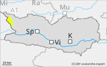
Danger level
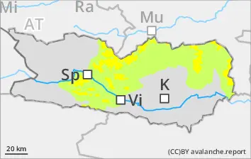
1700m
Avalanche Problem
New snow
1700m
Beware trigger-sensitive fresh fallen snow at high altitudes
The large amounts of fresh fallen snow and widespread snowdrift accumulations can easily be triggered above 2200m or else trigger naturally. Avalanches can fracture to lower layers and sweep them away, thereby grow to large size, which increases the runout zones. Due to solar radiation, increasingly frequent loose-snow avalanches can be expected during the course of the day, mostly small releases.
Snowpack
dp.4: cold following warm / warm following cold
Since Saturday, 30-40cm of fresh snow has been registered. The fresh fallen snow is prone to triggering. In the lowermost part of the snowpack on N/W/E-facing slopes there are faceted, expansively metamorphosed weak layers evident. Below 1700m: rainfall has made the snowpack thoroughly wet over far-reaching areas.
Tendency
Unchanged avalanche danger levels
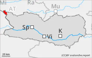
Danger level
1900m
Avalanche Problem
Wind slab
1900m
Avoid fresh snowdrift accumulations
Due to fresh fallen snow and strong-to-stormy northerly winds, further snowdrift accumulations are being generated esp. in gullies, bowls and behind protruberances in the terrain. Avalanches can be triggered in the weak old snow by one sole skier. Danger zones occur esp. on W/N/E-facing slopes above 2200m. Isolated danger zones also lie on south-facing slopes above 2600m. Avalanches can also be triggered in the near-surface layers of the snowpack in all aspects above 2200m. The releases can fracture down to deeper layers and thereby grow to medium size. Due to snowfall, increasingly frequent loose-snow avalanches can be expected, mostly small releases.
Snowpack
dp.6: cold, loose snow and wind
Since Saturday, 20-40cm of fresh snow has been registered above 1700m, locally up to 60cm. The often storm strength winds will transport the fresh snow intensively. Inside the old snowpack on N/W/E-facing slopes there are faceted, expansively metamorphosed weak layers. The fresh snowdrifts lie deposited atop soft layers above 2000m.