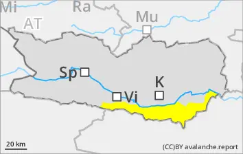
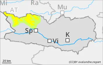
Runout zones of wet-snow avalanches should be avoided. Trigger-sensitive fresh snow requires attentiveness. Starting at midday, CONSIDERABLE danger level.
Naturally triggered small-to-medium wet avalanches will increase as rainfall sets in. On extremely steep slopes, small-to-medium wet loose-snow avalanches can be expected. Particularly at the foot of rock walls, small-to-medium wet slab avalanches are possible. Runout zones of wet-snow avalanches should be avoided. Above 1900m: lots of fresh snow expected which will be prone to triggering, also the freshly generated snowdrift accumulations, esp. in gullies and bowls in zones with wind impact. Avalanches can in isolated cases sweep along the thoroughly wet snowpack, which then lengthens the runout zone of the plummeting snow masses.
Snowpack
dp.3: rain dp.6: cold, loose snow and wind
Rainfall will make the snowpack thoroughly wet, esp. below 1900m. Above 1900m, 20-30cm of fresh snow anticipated. The fresh fallen snow is prone to triggering. In the lowermost part of the snowpack on N/W/E-facing slopes, faceted expansively metamorphosed weak layers threaten.
Tendency
Decreasing avalanche danger
Danger level
2000m
Avalanche Problem
Persistent weak layer
2000m
Wind slab
2200m
Beware fresh snowdrifts
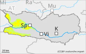
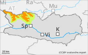
Fresh snowfall and strong-to-stormy northerly winds will generate new snowdrift accumulations esp. in gullies and bowls, behind protruberances in the terrain which can be triggered in the old snow and reach medium size, particularly in wind-protected zones. Even one sole skier can trigger avalanches. Danger zones occur esp. on W/N/E-facing slopes above 2200m. Very isolated danger zones occur also on south-facing slopes above 2600m. In isolated cases, avalanches can sweep along more deeply embedded layers of the snowpack. Danger zones and likelihood of triggering will increase during the course of the day. In addition, avalanches can trigger in the near-surface layers even by one sole skier, esp. in the afternoon in the wind-impacted zones.
Snowpack
dp.6: cold, loose snow and wind
Above 2000m, 5-10cm of fresh snow anticipated which will be transported by stormy winds. The fresh snowdrifts above 2200m will be deposited atop an unfavorable snowpack. In the uppermost part of the snowpack on N/W/E facing slopes, faceted expansively metamorphosed weak layers threaten.
Tendency
Little change expected
Danger level
1900m
Avalanche Problem
Wind slab
1900m
Avoid snowdrift accumulations
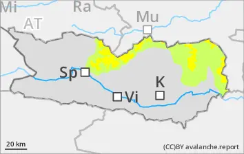
Fresh snowfall and strong-to-stormy northerly winds will generate new snowdrift accumulations esp. in gullies and bowls, behind protruberances in the terrain which can be triggered in the old snow and reach medium size, particularly in wind-protected zones. Even one sole skier can trigger avalanches. Danger zones occur esp. on W/N/E-facing slopes above 2200m. Very isolated danger zones occur also on south-facing slopes above 2600m. In isolated cases, avalanches can sweep along more deeply embedded layers of the snowpack. Danger zones and likelihood of triggering will increase during the course of the day.
Snowpack
dp.6: cold, loose snow and wind
Above 1900m, 20-30cm of fresh snow anticipated, locally more, which will be transported by often storm-strength winds, the freshly generated snowdrift accumulations above 2200m will be deposited atop an unfavorable old snowpack surface.
Tendency
No change expected
BEFORE NOON Danger level
2200m
Avalanche Problem
Persistent weak layer
2200m
AFTERNOON Danger level
2200m
Avalanche Problem
Persistent weak layer
2200m
Wind slab
2400m
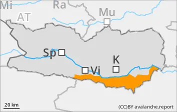
Avoid fresh snowdrifts. Starting at midday, CONSIDERABLE danger level.
Fresh snowfall and strong-to-stormy northerly winds will generate new snowdrift accumulations esp. in gullies and bowls, behind protruberances in the terrain which can be triggered in the old snow and reach medium size, particularly in wind-protected zones. Even one sole skier can trigger avalanches. Danger zones occur esp. on W/N/E-facing slopes above 2200m. Very isolated danger zones occur also on south-facing slopes above 2600m. In isolated cases, avalanches can sweep along more deeply embedded layers of the snowpack. Danger zones and likelihood of triggering will increase during the course of the day. In addition, avalanches can trigger in the near-surface layers even by one sole skier, esp. in the afternoon in the wind-impacted zones.
Snowpack
dp.6: cold, loose snow and wind
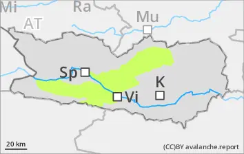
Especially along the Salzburg border, 20-30cm of fresh snow anticipated. The often storm-strength winds will transport the snow, the freshly generated snowdrift accumulations above 2200m will be deposited atop an unfavorable old snowpack surface. Inside the old snowpack on N/W/E-facing slopes, faceted expansively metamorphosed weak layers threaten. The fresh drifts above 2400m lie deposited atop weak layers.
Tendency
No change expected
Danger level
Avalanche Problem
Wet snow
Beware wet snow
On extremely steep slopes, generally small-sized wet loose-snow avalanches are possible. In addition, during the afternoon hours, mostly small wet slab avalanches are possible. Weak layers in the old snowpack can in isolated cases be triggered by one sole skier. Isolated danger zones occur on very steep shady slopes, esp. above 2000m. In addition, small snowdrift accumulations require caution, they can be triggered by one sole skier in isolated cases.
Snowpack
dp.3: rain
Rainfall will make the snowpack thoroughly wet, esp. below 1900m. In the lowermost part of the snowpack on N/W/E-facing slopes, faceted expansively metamorphosed weak layers threaten. Below the timberline there is only little snow on the ground.