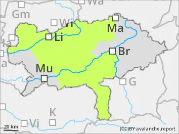
Danger level
 | 1800m |
|  |
|  |

![]()
Avalanche danger above 1.800 m moderate and below 1.800 m low. The main problem is fresh snowdrift. Danger spots are located in the north sector above 1.800 m. Small slab avalanches can be triggered by an alpinist in extremly steep slopes. Caution behind ridgelines. Due to sun radiation in places wet loose-snow avalanches are possible.
Snowpack
In the last 24 hours it had 10 to 20 cm new snow. The southern winds drifted the new snow to the northern sector. The peak of precipitation was between Turrach heights and Niedere Tauern. In high altitudes the fresh snowdrift is placed on top of a hard old snow cover or on top of faceted snow. In medium altitudes the snow is on top of meadows.
Tendency
Forecast for Saturday: dense clouds and the summits will be foggy and snowy. The snowline is 900 m in the north and 1.300 m in the south. During the afternoon precipitation will be weakening and it can clear up a little bit in the area of the foothills. Slightly increasing avalanche danger is to expect.