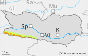
Due to fresh snow, likelihood of slab avalanches above 1800m. Avalanches can trigger in gullies, bowls, behind protruberances in the terrain in the near-surface layers, even by one sole skier. Also isolated naturally triggered avalanches are possible, more so if the precipitation intensifies, esp. at the foot of rock walls. Avalanches can trigger in the old snowpack and grow to medium size. Whumpf noises and naturally triggered releases are alarm signals, indicators of imminent danger. Below 1800m: naturally triggered wet-snow avalanche activity will increase with the beginning of rainfall. In starting zones which have not yet discharged, small-to-medium wet loose-snow avalanches are possible,. The runout zones should be circumvented, esp. on extremely steep slopes below 1800m in all aspects, esp in the afternoon in case of extended bright intervals.
Snowpack
dp.6: cold, loose snow and wind dp.1: deep persistent weak layer
Since Monday, especially along the Italian border, about 40-50 cm of fresh snow was registered above 2000m, locally more. Above 1600m 10-20cm of fresh snow is anticipated widespread. Winds will transport the fresh snow. Fresh snow and drifts will be deposited on shady slopes above 2000m atop an unfavorable old snowpack surface. There are expansively metamorphosed layers deeply embedded inside the snowpack, esp above 2000m. Below 2000m: rainfall in all aspects will lead to increasing wettening of the snowpack below 1800m. Nocturnal outgoing longwave radiation is heavily reduced.
Tendency
Increasing avalanche danger
Danger level
2000m
Avalanche Problem
Wind slab
2000m
Beware snowdrifts
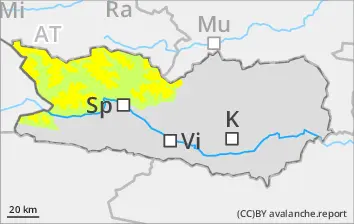
Due to fresh snow and moderate-velocity southerly winds, trigger-sensitive snowdrift accumulations have been generated esp. in ridgeline terrain, in gullies and bowls, esp. above 2400m. Avalanches can be triggered by persons in the uppermost layers. In addition, isolated avalanches can fracture down to deeper layers of the snowpack and then grow to medium size. In starting zones which have not yet discharged, mostly small wet loose snow avalanches are possible, and can be triggered by winter sports enthusiasts. Caution urged in extremely steep slopes below 2000m. In addition, in the major areas of precipitation, isolated mostly small glide-snow avalanches are possible.
Snowpack
dp.6: cold, loose snow and wind dp.1: deep persistent weak layer
Since Monday above 2000m, 5-10 cm of fresh snowfall has been registered, locally more. Widespread 10-15 cm of fresh snow is anticipated during the nocturnal hours. Winds will transport the fresh snow and some of the old snow. Fresh snow and drifts will be deposited on shady slopes above 2000m atop an unfavorable old snowpack surface. In the lowermost part of the snowpack on shady slopes, faceted weak layers are evident.
Tendency
Increasing avalanche danger
Danger level
1900m
Avalanche Problem
Wind slab
1900m
Wet snow
1900m
Caution: freshly generated snowdrifts
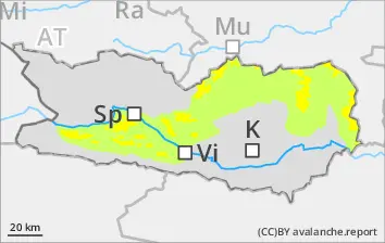
Due to fresh fallen snow and often strong-velocity winds from the south, trigger-sensitive snowdrift accumulations will be generated esp. on ridgeline slopes, in gullies and bowls above 1900m. Avalanche releases are mostly small but can be triggered by one sole skier. Isolated wet loose-snow avalanches are possible in starting zones which have not yet discharged, esp. on extremely steep slopes below 1900m.
Snowpack
dp.6: cold, loose snow and wind
Above 1900m: tonight 10-15 cm of fresh snow is expected. Often strong velocity winds will transpoft the fresh snow, new snowdrifts will be deposited atop an unfavorable old snowpack surface. Below 1900m: rainfall will make the snowpack thoroughly wet. Nocturnal outgoing longwave radiation is much reduced.
Tendency
Slight rise in avalanche danger
Danger level
1800m
Avalanche Problem
Wet snow
1800m
Wind slab
1800m
Caution: wet loose-snow avalanches. Runout zones should be circumvented.
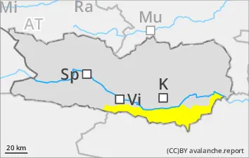
Naturally triggered activity of wet-snow avalanches will increase as rainfall sets in. In starting zones which have not yet discharged, small-to-medium wet loose-snow avalanches are possible. The runout zones should be circumvented, esp. on extremely steep slopes below 1800m in all aspects. Due to fresh snowfall and often strong-velocity winds from the south, trigger-sensitive snowdrift accumulations will be generated esp. on ridgeline slopes, in gullies and bowls above 1800m. Avalanches can in isolated cases fracture down to more deeply embedded layers inside the snowpack and sweep them along. Avalanche releases are often medium-sized, triggerable by one sole skier. Rainfall will lead to an increased wettening of the old snowpack below 1800m in all aspects. Caution in gullies along the Slovenian border.
Snowpack
dp.3: rain dp.6: cold, loose snow and wind
Rainfall in all aspects will make the snowpack generally wetter below 1800m. Since Monday, especially along the Slovenian border, about 5-10 cm of fresh snow was registered above 1900m, locally more. Above 1800m 15-20cm of fresh snow is anticipated widespread. Winds will transport the fresh snow. Fresh snow and drifts will be deposited on shady slopes above 2000m atop an unfavorable old snowpack surface.