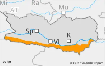
Danger is upperline-border of Danger Level 3 (“considerable”) above 1800m. Naturally triggered avalanches expected.
Naturally triggered avalanche acdtivity will increase as intensive snowfall sets in. Avalanches can be triggered in the old snow and on shady slopes, then grow to large size. In addition, avalanches can be triggered by one sole skier in the near-surface layers. I isolated cases, avalanches can also fracture the wet snowpack and sweep it along. Caution urged at the foot of rock walls and behind protruberances in the landscape, as well as in gullies and bowls. Activity of small-to-medium loose-snow avalanches will increase significantly during the course of the day. The runout zones should be circumvented. On extremely steep grass-covered slopes, isolated glide-snow avalanches are possible during the afternoon hours, also medium-sized releases. The current situation makes extreme caution imperative.
Due to fresh snow, likelihood of slab avalanches above 1800m. Avalanches can trigger in gullies, bowls, behind protruberances in the terrain in the near-surface layers, even by one sole skier. Also isolated naturally triggered avalanches are possible, more so if the precipitation intensifies, esp. at the foot of rock walls. Avalanches can trigger in the old snowpack and grow to medium size. Whumpf noises and naturally triggered releases are alarm signals, indicators of imminent danger. Below 1800m: naturally triggered wet-snow avalanche activity will increase with the beginning of rainfall. In starting zones which have not yet discharged, small-to-medium wet loose-snow avalanches are possible. The runout zones should be circumvented, esp. on extremely steep slopes below 1800m in all aspects.
Snowpack
dp.6: cold, loose snow and wind dp.1: deep persistent weak layer
Since Wednesday above 1800m, about 30-40 cm of fresh snow has been registered, locally more. Above 1600m 30-50cm of fresh snow. Winds are transporting the fresh snow. Fresh snow and drifts are being deposited on shady slopes above 1800m atop an unfavorable old snowpack surface (soft layers). More deeply embedded inside the snowpack, esp. on shady slopes, there are expansively metamorphosed (faceted) weak layers, esp. above 2000m. Below 1800m: rainfall is leading to the snowpack becoming thoroughly wet over far-reaching areas. Nocturnal outgoing longwave radiation is much reduced.
Tendency
Increasing avalanche danger
Danger level
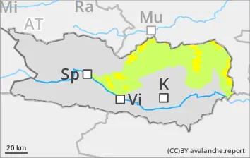
1900m
Avalanche Problem
Wind slab
1900m
Persistent weak layer
2000m
Beware snowdrifts
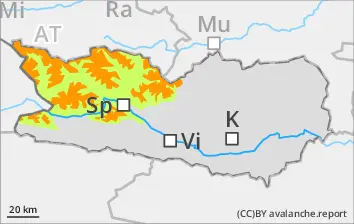
Due to fresh snow and strong-to-storm velocity southerly winds, trigger-sensitive snowdrift accumulations have been generated esp. in ridgeline terrain, in gullies and bowls, esp. above 1900m. Avalanches can be triggered by persons or trigger naturally. In addition, isolated avalanches can fracture down to deeper layers of the snowpack and then grow to medium size. In starting zones which have not yet discharged, mostly small wet loose snow avalanches are possible, and can be triggered by winter sports enthusiasts. Isolated danger zones occur on wind-protected sunny slopes above 2500m, releases mosetly medium-sized. Fracture upon treading the snowpack are indicators of imminent danger, mostly small glide-snow avalanches are possible an extremely steep slopes.
Snowpack
dp.6: cold, loose snow and wind dp.1: deep persistent weak layer
Since Wednesday above 2000m, about 15-20 cm of fresh snow has been registered, locally more. Above 1600m 20-30cm of fresh snow. Winds are transporting the fresh snow. Fresh snow and drifts are being deposited on shady slopes above 1800m atop an unfavorable old snowpack surface (soft layers). More deeply embedded inside the snowpack, esp. on shady slopes, there are expansively metamorphosed (faceted) weak layers, esp. above 2000m. Below 1800m: rainfall is leading to the snowpack becoming thoroughly wet over far-reaching areas.
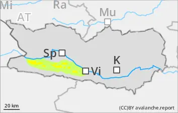
Due to fresh snow and strong-to-storm velocity southerly winds, trigger-sensitive snowdrift accumulations have been generated esp. above 1800m on NW/N/NE facing slopes, in gjullies and bowls, and behind protruberances in the terrain. Avalanches can be triggered by persons or trigger naturally. In addition, very isolated avalanches can fracture down to deeper layers of the snowpack and then grow to medium size, mostly small wet loose snow avalanches are possible, and can be triggered by winter sports enthusiasts. Isolated danger zones occur on wind-protected sunny slopes above 2500m, releases mostly medium-sized, on extremely steep slopes.
Snowpack
dp.6: cold, loose snow and wind
Since Wednesday above 1800m, about 10-15 cm of fresh snow has been registered, locally more. Another 15-20cm cm of fresh snow is still expected. Winds are transporting the fresh snow. Fresh snow and drifts are being deposited on shady slopes above 1800m atop an unfavorable old snowpack surface (soft layers).
Tendency
Increasing avalanche danger
Danger level
1900m
Avalanche Problem
Wind slab
1900m
Wet loose-snow avalanches are hardly possible.
Due to fresh snow and strong-to-storm velocity southerly winds, trigger-sensitive snowdrift accumulations have been generated esp. above 1900m on NW/N/NE facing slopes, in gullies and bowls, and behind protruberances in the terrain. Avalanches can grow to medium size, and can be triggered by winter sports enthusiasts.
Snowpack
dp.6: cold, loose snow and wind
Since Wednesday above 1900m, about 10-15 cm of fresh snow has been registered, locally more. Another 15-20cm cm of fresh snow is still expected. Winds are transporting the fresh snow. Fresh snow and drifts are being deposited on shady slopes atop an unfavorable old snowpack surface (soft layers).