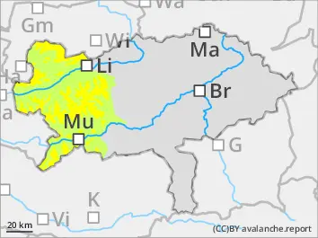
Moderate avalanche danger in high altitudes - caution: fresh snowdrift!
The avalanche danger is moderate above 1.600 m. Danger spots are predominantly in northwest to eastern expositions. There fresh snowdrift accumulations are formed on a weakened old snow cover. Especially in entry and peripheral areas to extrem steep gullies and bowls slave avalanches can be triggered which can reach medium sizes.
Snowpack
The snowcover is in general unusually thin considering the season. On sunny slopes the snow cover is already moist partially wet down to the ground even in high altitudes. Fresh new snow (maximum 30 cm) is drifted with the stormy winds to north and eastern expositions and is accumulating there and prone to triggering. The bonding to the old snow layer decreases with altitude. The old snow base is built by a succession of soft layers built of faceted snow crystals and melt-freeze crusts and weakened especially in shady slopes in medium and high altitudes.
Tendency
Wednesday will be sunny but the summits will be foggy. Temperatures in 2.000 m are around-4 degrees. No significant changes of the avalanche danger is expected.
Danger level
1800m
Avalanche Problem
Persistent weak layer
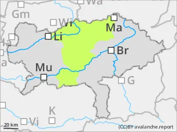
1800m
Little new snow - avalanche danger low.
The avalanche danger is low. Only in some places in high altitudes an extremely steep and shady gullies and bowls small slab avalanches are possible. In case of triggered avalanches risk of injuries is more likely than risk of being buried.
Snowpack
The snow cover is unusual thin for this season and southern slopes as well as exposed areas are predominatly bare. The new snow accumulates predominantly in north to eastern expositions in from of snowdrift deposits. The old snow base is mostly wet, but in steep shady gullies are soft layers built by faceted snow crystals and melt-freeze crusts which are weakened.
Tendency
Tuesday will be cloudy with snowfall down to 1.000 m. In the area of Turrach around 30 cm of new snow is expected. In the north andh east less new snow in the Triebener Tauern around 10 cm. Due to fresh snowdrift the avalanche danger rises a little bit.