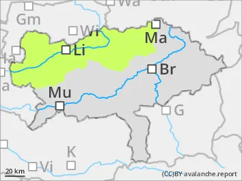
The avalanche danger is low. Only in some places in high altitudes an extremely steep and shady gullies and bowls small slab avalanches are possible. In case of triggered avalanches risk of injuries is more likely than risk of being buried.
Snowpack
The snow cover is unusual thin for this season and southern slopes as well as exposed areas are predominatly bare. An area-wide, coesive snow base is only existing in blown-in gullies and bowls and shady high-altitude slopes. That snow cover is in moist and charactized by equilibrium (isothermal) metamorphosis. It is succession of soft layers on the surfaces, partially powder snow, and faceted snow crystals with melt-freeze crusts.
Tendency
Tuesday will be cloudy with snowfall down to 1.000 m. In the area of Turrach around 30 cm of new snow is expected. In the north andh east less new snow in the Triebener Tauern around 10 cm. Due to fresh snowdrift the avalanche danger rises a little bit.
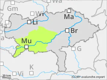
Danger level
1800m
Avalanche Problem
Persistent weak layer
1800m
Low avalanche danger. Persistent weak layers in high altitudes.
The avalanche danger is in general low. Persistent weak layers above 1.800 m. Danger spots are usually located in shady northwesterly to southeasterly expositions, especially in entries to extremely steep gullies and bowls. Here medium-sized slab avalanches can be triggered by high additional loads.
Snowpack
The snowcover is in general unusually thin considering the season. Only in blown-in gullies and bowls higher amounts of compact snow is found. On sunny slopes the snow cover is already moist even in high altitudes. On the surface hoar is forming. On shady slopes in medium and high altitudes a succession of soft layers built of faceted snow crystals and melt-freeze crust is found. The bonding is poor and the snow base is weak.
Tendency
Tuesday will be cloudy with snowfall down to 1.000 m. In the area of Turrach around 30 cm of new snow is expected. In the north andh east less new snow in the Mürzsteger Alps around 5 cm. Due to fresh snowdrift the avalanche danger rises a little bit.