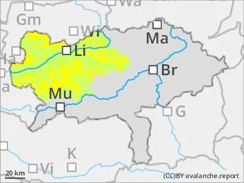
The avalanche danger is assessed as moderate above the tree line. Attention must be paid to the drift snow and persistent weak layers. The danger spots are in the north and east sectors. It cannot be completely ruled out that a slab avalanche can be triggered by a small additional load. In some areas, avalanches can tear through layers of old snow close to the ground and become medium-sized.
Snowpack
Between 5 and 20 cm of fresh snow has fallen since Tuesday. The greatest amount of fresh snow was in the Totes Gebirge. The snow initially fell with light winds. On Thursday strong south-westerly winds will bring snow to the northern and eastern sectors. The fresh snow has mostly covered an icy layer at high altitudes or snowed over the meadow again. Below the layer of fresh snow, there is still a more or less continuous snow cover only at high altitudes and on the shady slopes. The old snow cover is weakened in places by faceted snow crystals.
Tendency
On Friday, icy polar air will penetrate Austria behind a cold front, leading to a significant drop in temperature on the mountains. It will be accompanied by a little snowfall and a stormy north-westerly wind in the Nordstau. The risk of avalanches increases slightly.
Danger level
1900m
Avalanche Problem
Wind slab
1900m
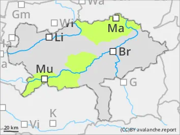
Low avalanche danger - only isolated danger spots due to fresh drift snow.
The avalanche danger is low. There are isolated danger spots. These are located in high, shady, very steep entrances to gullies and bowls, especially in northern and eastern exposures. Small slab avalanches can be triggered here in wind drifted snow by even a low additional load. In addition to the danger of burying, the risk of being swept away and falling should also be taken into account.
Snowpack
Between 5 and 20 cm of fresh snow has fallen since Tuesday. The snow initially fell with light winds. On Thursday strong south-westerly winds will bring snow to the northern and eastern sectors. The fresh snow has mostly covered an icy layer at high altitudes or snowed over the meadow again. Below the layer of fresh snow, there is still a more or less continuous snow cover only at high altitudes and on the shady slopes. The old snow cover is weakened in places by faceted snow crystals.
Tendency
On Friday, icy polar air will penetrate Austria behind a cold front, leading to a significant drop in temperature on the mountains. It will be accompanied by a little snowfall and a stormy north-westerly wind in the Nordstau. As only a little fresh snow is expected in the south, the avalanche risk will only increase slightly.