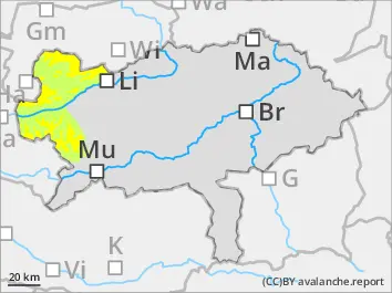
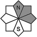
The avalanche danger is assessed as moderate above the tree line. Attention must be paid to the drift snow and persistent weak layers. The danger spots are in the north and east sectors. It cannot be completely ruled out that a snow slab can be triggered by a small additional load. In places, avalanches can tear through layers of old snow close to the ground and become medium-sized. As the weather warms up, wet loose snow slides are also possible from steep rocky and rugged terrain.
Snowpack
10 to 20cm of fresh snow has fallen in the last 24 hours. The largest amount of fresh snow was in the Totes Gebirge, with up to 20cm. Up to 10cm of fresh snow was recorded in the Niedere Tauern. The fresh snow covers hard or icy old snow surfaces. Under the hard layer, the accumulating transformation weakens the snowpack foundation. As it warms up, the new snow becomes sticky up to the middle layers. The snowpack can settle. In general, the snow cover is very unevenly distributed, with little snow from the middle layers downwards.
Tendency
It will remain mild. Thursday will start off overcast, with some snow or rain possible in the western mountain ranges. The weather will improve during the day as a strong south-westerly wind picks up and the sun will shine again and again during the day, especially to the north and east. The temperature will be around 0 degrees at an altitude of 2000m.
Danger level
treeline
Avalanche Problem
New snow
Treeline
-
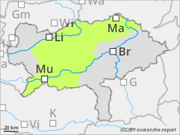
Low avalanche danger - fresh snow covering the meadows.
The avalanche danger is low. There are isolated danger spots. These are located in high, shady, very steep entrances to gullies and hollows. Small slab avalanches can be triggered here in drifting snow, particularly due to high additional loads. In addition to the risk of burial, the danger of being swept away and falling should also be taken into account.
Snowpack
Between 5 and 20cm of fresh snow has fallen in the last 24 hours. The largest amounts of snow (20cm) have fallen in the Wölzer Tauern, but with little wind. The fresh snow has mostly covered an icy layer at high altitudes or snowed over the green meadow again. Below the layer of fresh snow, there is still a more or less continuous snow cover only at high altitudes and on the shaded side. The old snow cover is partially weakened by angular crystals.
Tendency
Thursday will start off overcast, with a possibility of snow or rain in the western mountain ranges. The weather will improve during the day as a strong south-westerly wind picks up and the sun will shine again and again during the day, especially to the north and east. At 2000m it will be around 0 degrees at midday.