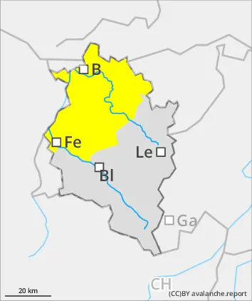
Above the treeline, snowdrifts. Loose-snow and glide-snow avalanches due to higher temperatures.
Above the treeline, fresh snowdrift accumulations are prone to triggering. Danger zones occur mostly on shady slopes behind protruberances in the landscape, in gullies and bowls and on wind-loaded slopes. Small, in isolated cases medium-sized avalanches can be triggered even by one single skier. At low altitudes, paricularly on sunny slopes, moist loose-snow avalanches and small glide-snow avalanches are possible on steep grassy slopes.
Snowpack
The latest bout of fresh snowfall is being deposited mostly on steep shady slopes atop metamorphosed old snowpack layers or atop surface hoar. On east-facing and sunny slopes, often atop encrusted surfaces. As a result of strong NW winds, widespread snowdrifts will accumluate. The fresh snow will be increasely poorly bonded with the old snowpack surface with ascending altitude. In places in high-altitude shady spots and where the snow is shallow, weak faceted layers are evident in the snowpack. All in all, the snowpack is highly varied: ridges are often windblown, gullies and bowls are filled to the brim with snow.
Tendency
Tuesday will be quite sunny and mild. Avalanche dangers are not expected to change significantly. Slides and small glide-snow avalanches are still possible.
Danger level
2000m
Avalanche Problem
Wind slab
2000m
Wet snow
2000m
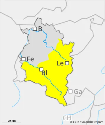
Fresh snowdrifts are main danger. Loose-snow and glide-snow avalanches due to higher temperatures.
At high altitudes, fresh snowdrift accumulations are prone to triggering. Danger zones occur mostly on shady slopes behind protruberances in the landscape, in gullies and bowls and on wind-loaded slopes. Size and spread tend to increase with ascending altitude. Small-to-medium slab avalanches can be triggered even by the weight of one single skier. At low altitudes and particularly on sunny slopes, moist loose-snow avalanches and small-to-medium glide-snow avalanches can trigger due to the higher temperatures.
Snowpack
The fresh snowfall is being deposited mostly on steep shady slopes atop metamorphosed old snowpack layers or atop surface hoar. On east-facing and sunny slopes, often atop encrusted surfaces. As a result of strong NW winds, widespread snowdrifts will accumluate. The fresh snow will be increasely poorly bonded with the old snowpack surface with ascending altitude. In places in high-altitude shady spots and where the snow is shallow, weak faceted layers are evident in the snowpack. All in all, the snowpack is highly varied: ridges are often windblown, gullies and bowls are filled to the brim with snow.
Tendency
The zero-degree level will ascend to nearly 3000m on Tuesday. High-altitude winds will be westerly, blowing at strong-to-stormy velocity. Snowdrifts are the main danger at high altitudes. At low altitudes, slides and glide-snow avalanches are possible.