At high altitudes, fresh snowdrift accumulations are prone to triggering. Danger zones occur mostly on shady slopes behind protruberances in the landscape, in gullies and bowls and on wind-loaded slopes. Size and spread tend to increase with ascending altitude. Small-to-medium slab avalanches can be triggered even by the weight of one single skier. Above 2400m, isolated avalanches can trigger in the old snow and grow to medium size. Below the trereline, avalanche danger is low.
Snowpack
The fresh snowfall is being deposited mostly on steep shady slopes atop metamorphosed old snowpack layers or atop surface hoar. On east-facing and sunny slopes, often atop encrusted surfaces. As a result of strong NW winds, widespread snowdrifts will accumluate. The fresh snow will be increasely poorly bonded with the old snowpack surface with ascending altitude. In places in high-altitude shady spots and where the snow is shallow, weak faceted layers are evident in the snowpack. All in all, the snowpack is highly varied: ridges are often windblown, gullies and bowls are filled to the brim with snow.
Tendency
Monday will be sunny and noticeably milder. Avalanche danger levels will decrease., but slides and small glide-snow avalanches are possible.
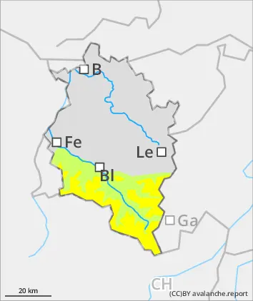
Danger level
2000m
Avalanche Problem
Wind slab
2000m
Persistent weak layer
2400m
Fresh snowdrifts are main danger
Above 2000m, fresh snowdrift accumulations are prone to triggering. Danger zones occur mostly on shady slopes behind protruberances in the landscape, in gullies and bowls and on wind-loaded slopes. Size and spread tend to increase with ascending altitude. Small-to-medium slab avalanches can be triggered even by the weight of one single skier. Above 2400m, isolated avalanches can trigger in the old snow and grow to medium size. Below the trereline, avalanche danger is low.
Snowpack
The fresh snowfall is being deposited mostly on steep shady slopes atop metamorphosed old snowpack layers or atop surface hoar. On east-facing and sunny slopes, often atop encrusted surfaces. As a result of strong NW winds, widespread snowdrifts will accumluate. The fresh snow will be increasely poorly bonded with the old snowpack surface with ascending altitude. In places in high-altitude shady spots and where the snow is shallow, weak faceted layers are evident in the snowpack. All in all, the snowpack is highly varied: ridges are often windblown, gullies and bowls are filled to the brim with snow.
Tendency
Monday will be sunny and noticeably milder. Avalanche danger levels will decrease. Increasingly frequent slides and small glide-snow avalanches are possible.
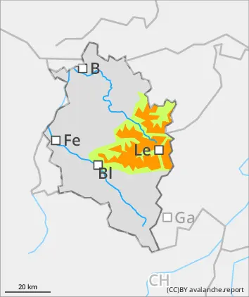
Danger level
treeline
Avalanche Problem
Wind slab
Treeline
Above the treeline, snowdrifts demand caution
Above the treeline, fresh snowdrift accumulations are prone to triggering. Danger zones occur mostly on shady slopes behind protruberances in the landscape, in gullies and bowls and on wind-loaded slopes. Below the trereline, avalanche danger is low.
Snowpack
The fresh snowfall is being deposited mostly on steep shady slopes atop metamorphosed old snowpack layers or atop surface hoar. On east-facing and sunny slopes, often atop encrusted surfaces. As a result of strong NW winds, widespread snowdrifts will accumluate. The fresh snow will be increasely poorly bonded with the old snowpack surface with ascending altitude. In places in high-altitude shady spots and where the snow is shallow, weak faceted layers are evident in the snowpack. All in all, the snowpack is highly varied: ridges are often windblown, gullies and bowls are filled to the brim with snow.
Tendency
Monday will be sunny and noticeably milder. Avalanche danger levels will decrease. Slides and small glide-snow avalanches are possible.