Danger level
 | 2400m |
|  |
|  |

![]()
Starting at midday, avalanche danger is expected to rise.
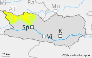
As a result of fresh fallen snow and frequently storm-strength NW winds, fresh snowdrifts are accumulating. The fresh snowdrifted masses can easily be triggered above 2400m in all aspects, or else trigger naturally, particularly at the foot of cliffs and behind protruberances in the landscape along the Salzburg border in those regions where there is lots of wind. Avalanches are medium-sized in isolated cases. Apart from the risks of being buried in snow masses, also the danger of being swept along and being forced to take a fall need to be considered.
Snowpack
dp.6: cold, loose snow and wind
From place to place, 5-15 cm of snowfall is anticipated, locally more. Winds will be blowing intermittently at storm-strength. Freshly generated snowdrift accumulations are poorly bonded with each other and with the old snow. The upper layers of the snowpack are soft; the lower layers are faceted.
Tendency
Forecasts of developments, including of avalanche danger, are still uncertain.