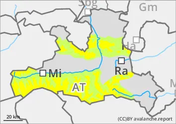
Avalanche prone locations in wind slab, in the higher altitudes also in persistent weak layers
The avalanche risk is moderate from the sparse high forest upwards. The last wind slab can be triggered in some places with little additional load, slab avalanches can reach medium size. All aspects and both adjacent to ridgelines and steep terrain far from ridgelines are affected. At higher elevations (especially on western, northern and eastern slopes), avalanches can also break through into the persistent weak layer and occasionally become large if the additional load is high. The drift snow areas are not recognisable everywhere. Small gliding avalanches are occasionally possible on very steep sunny slopes.
Snowpack
The abundant new fallen snow that fell under stormy conditions from the west to north in the middle of the week has settled significantly and is already slightly moistened and crusted on sunny slopes up to over 2000 metres. In exposed areas, the snowpack is marked by the storm, with 5 to 10 centimetres of new fallen snow covering the wind tracks. Fractures are possible, especially in the last wind slab, but also partly in the old snowpack, in which faceted crystals (partly on crusts) and deep rime weaken the structure both near the surface and deeper inside. This mainly affects high altitudes on shady slopes (W-N-E) and high alpine locations.
Tendency
Between 10 and 30 cm of new fallen snow by Tuesday. The risk of slipping snow increases.
Danger level
treeline
Avalanche Problem
Wind slab
Treeline
Persistent weak layer
2000m
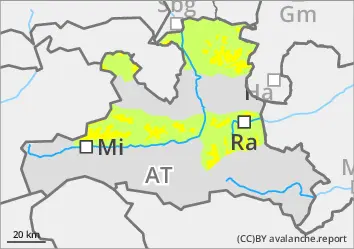
Consistently avoid fresh wind slab!
The avalanche risk is moderate above the tree line. Fresh wind slabs can be triggered as small or medium-sized slabs in all aspects, even under low loads. Avalanche prone locations are mainly in gullies, bowls and behind terrain edges, also distant from ridgelines. Take particular care on very steep western, northern and eastern slopes above around 2000 metres. Transitions from little to more snow are particularly unfavourable.
Snowpack
The snow surface is characterised by the north-westerly storm of the last few days and the wind is also depositing fresh wind slab. It covers an unfavourable old snow surface above the tree line. Breaks are possible between the drift snow layers and at the transition to the persistent weak layer. The old snowpack is particularly weakened on western, northern and eastern slopes above around 2000 metres by layers of faceted crystals and deep frost as well as by a foundation of floating snow close to the ground.
Tendency
No significant change on Tuesday.
Danger level
treeline
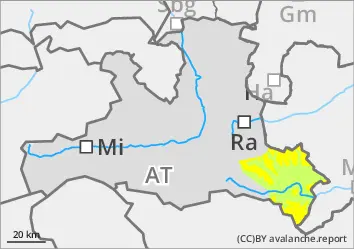
Avalanche Problem
Wind slab
Treeline
Gliding snow
1500m
The wind slab can be triggered even with a small additional load
The avalanche risk is moderate. Above the tree line, the last wind slab can be triggered as a snow slab in some places even with little additional load. Avalanches can reach medium size. There are avalanche prone locations both adjacent to ridgelines and distant from ridgelines, as well as in steep gullies and in forest aisles. The wind slab is partly covered with snow away from areas adjacent to the ridgeline, crest or summit and the avalanche prone locations are not recognisable everywhere. Spontaneous small gliding avalanches are possible on very steep grassy slopes.
Snowpack
The abundant new fallen snow that fell in the middle of the week under the influence of strong winds from the west to north has settled significantly. On the sunny slopes, it has already been slightly moistened again and covered with a thin crust. Protected from the wind, there is 5 to 10 cm of soft new fallen snow on this base. On the sunny slopes, the snow often lies on previously apery soils up to medium altitudes, on shady slopes on an old snowpack weakened by angular forms (partly also on crusts) and by deep frost. Fractures are mainly possible within the fresh drift snow layers, but in shady high altitudes sometimes also in the persistent weak layer. On very steep sunny slopes, the snow occasionally glides along the ground.
Tendency
Between 10 and 30 cm of new fallen snow by Tuesday. The risk of slipping snow increases.