Snowfall above 2300m accompanied by brisk westerly winds, thus transporting it. Frequency and magnitude of danger zones will increase with ascending altitude. In addition, winter sports enthusiasts can trigger isolated avalanches in near-surface weak layers on high-altitude shady slopes. Such danger zones are impossible to recognize. Due to daytime warming and rainfall initially up to 2300m, danger of wet-snow avalanches will increase in morning hours. Wet slab avalanches can be triggered by winter sports enthusiasts. Also isolated naturally triggered wet-snow avalanches are possible. Caution urged above all towards steep shady slopes at 2200-2500m which have not yet discharged and generally slopes in aspects where there is still area-wide snow on the ground. Avalanches can fracture in weak old snowpack layers, in isolated cases grow to large size and have atypically long runout zones. Whumpf noises and breaking through the surface crusts of old snow are indicators of danger. On snowy, steep slopes with smooth underground (such as grass-covered slopes and rock plates) which have not yet discharged, glide-snow avalanches can trigger in all aspects.
Snowpack
In evening hours, outgoing radiation will still be effective, but during nighttime hours due to heavy cloud cover, increasingly limited. In early morning hours, rain showers will set in up to 2300m. As showers increase, the snowfall level will drop to about 1800m during the day. At 1800-2500m the ground-level rotten snow is thoroughly wet and prone to triggering, also on north-facing slopes. Lower altitudes are already bare of snow. On sunny slopes the round is becoming bare of snow up to high altitudes. Iin high-altitude, shady steep terrain there are unfavorable intermediate layers in the uppermost layer of the snowpack which can, in places, be triggered. A deep mid-level sector of the snowpack consists of compact layers blanketing a fundament of buried hoar and faceted crystals.
Tendency
Wet-snow avalanche activity will recede as temperatures drop
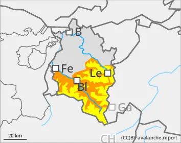
Danger level
Avalanche Problem
Wet snow
Wet-snow danger in very steep terrain where there is still lots of snow
Snowfall above 2300m accompanied by brisk westerly winds, thus transporting it. Due to daytime warming and rainfall initially up to 2300m, danger of wet-snow avalanches will increase in morning hours. Wet slab avalanches can be triggered by winter sports enthusiasts. Also isolated naturally triggered wet-snow avalanches are possible. Caution urged above all towards steep shady slopes at 2200-2500m which have not yet discharged and generally slopes in aspects where there is still area-wide snow on the ground. Avalanches can fracture in weak old snowpack layers, in isolated cases grow to large size and have atypically long runout zones. Whumpf noises and breaking through the surface crusts of old snow are indicators of danger. On snowy, steep slopes with smooth underground (such as grass-covered slopes and rock plates) which have not yet discharged, glide-snow avalanches can trigger in all aspects.
Snowpack
In evening hours, outgoing radiation will still be effective, but during nighttime hours due to heavy cloud cover, increasingly limited. In early morning hours, rain showers will set in up to 2300m. As showers increase, the snowfall level will drop to about 1800m during the day. The snowpack is thoroughly wet up to summit zones in all aspects. Lower altitudes are bare of snow. Sunny slopes are becoming bare of snow up to high altitudes.
Tendency
Wet-snow avalanche activity will recede as temperatures drop
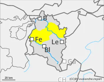
Danger level
Avalanche Problem
Wet snow
Small wet-snow slides possible
On extremely steep slopes, persons can in isolated cases trigger wet loose-snow slides where there is still sufficient snow on the ground.
Snowpack
In evening hours, outgoing radiation will still be effective, but during nighttime hours due to heavy cloud cover, increasingly limited. In early morning hours, rain showers will set in up to 2300m. As showers increase, the snowfall level will drop to about 1800m during the day. The snowpack is thoroughly wet. Lower altitudes are bare of snow. Sunny slopes are becoming bare of snow up to high altitudes. Where there is a snowpack on the ground it is thoroughly wet.
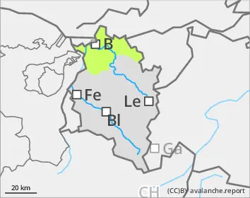
Tendency
Wet-snow avalanche activity will recede as temperatures drop