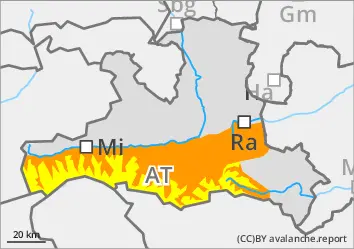
The avalanche risk is already considerable below around 2800 m in the morning. Steep areas in the extended northern sector between 2100 m and 2600 m are particularly at risk. Although a melt-freeze crust forms overnight, especially at this altitude, it quickly softens. Wet slab avalanches and loose snow avalanches are to be expected on slopes that have not yet been discharged. This occurs in those aspects where there is still a lot of snow, i.e. also on the south side at high altitudes. Most avalanches are naturally triggered avalanches, with remote triggering possible in isolated cases. Avalanches can become large in some places as wet snow collects and tears through the persistent weak layer and reach atypically long runout lengths. Caution should also be exercised in the apery areas of trenches. There are isolated signs of sliding snow activity.
In a few places above 2400 m, weak layers can also be disturbed directly in the persistent weak layer, especially on west, north and east-facing slopes, and also on the south side in the high Alps. Snow slabs in the dry persistent weak layers remain predominantly medium sized.
Snowpack
The snowpack cools down poorly overnight, only at altitude does a melt-freeze crust form, which softens quickly. There is compact snow underneath, but softer layers are embedded, especially at higher altitudes, which allow fractures near the surface. On shady slopes from around 2400 metres, there are still weak layers of angular forms and deep rime in the old snowpack close to the ground. The snowpack becomes moist to wet up to high altitudes during daytime changes at the latest. Low and sunny slopes are covered in snow.
Tendency
The night to Friday will be mostly clear and there will be pronounced daytime changes.
Danger level
Avalanche Problem
Wet snow
Persistent weak layer
2200m
Wet snow avalanches detach up to the summit areas
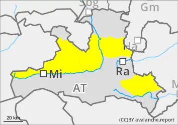
The avalanche risk is moderate. The melt-freeze crust at higher elevations is softening quickly. Wet loose snow and slab avalanches are already possible in the morning on slopes that have not yet been unloaded, with the danger increasing again slightly in the afternoon. This is the case in those aspects where there is still a lot of snow. Avalanches can occur naturally or be triggered by winter sports. They usually remain medium in size, but with the accumulation of wet snow and tearing through to weak layers close to the ground, large avalanches are conceivable in exceptional cases. Caution should also be exercised in the shallow outlet areas of trenches. Small gliding sluffs are occasionally recorded.
Trigger points for dry old snow avalanches are only present at a few high points in the extended northern sector.
Snowpack
The snowpack cools down poorly overnight, only at high altitudes does a thin melt-freeze crust form, which softens quickly. Underneath is compact snow, but on shady slopes from around 2200 metres there are still weak layers of deep rime in the old snowpack near the ground. The snowpack will become moist to wet up to high altitudes during the daytime changes at the latest. Low and sunny slopes are snowed out.
Tendency
The night to Friday will be mostly clear and there will be pronounced daytime changes.
Danger level
Avalanche Problem
Wet snow
Small wet snow avalanches in snowy places
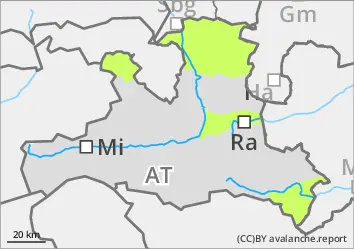
The avalanche risk is low. The last remnants of snow can spontaneously descend as small wet snow slides. This increases the risk of avalanches in the fall terrain.
Snowpack
The outgoing longwave radiation at night is poor and the snow cover remains largely isothermal. There is still a little snow in places at altitude, but most of the terrain is already snowed out.
Tendency
Gradual reduction in the avalanche risk as the remaining snow melts and rains away. The night to Friday will be mostly clear.