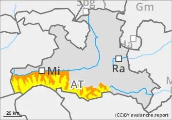
The wet snow problem remains, above 2200 m there are avalanche prone locations in the drift and persistent weak layer.
The avalanche risk is considerable below 2200 m and moderate above. Wet loose snow and slab avalanches are possible in all aspects on slopes below around 2200 m that have not yet been discharged. The avalanches can occur spontaneously or be triggered by individuals. They usually remain medium in size, but in isolated cases they can also become large. Above 2200 m, small slab avalanches can be triggered in fresh wind slab in some places. The number and size of snowdrift accumulations increase slightly with altitude. In a few places above 2200 m, weak layers in the persistent weak layer can also be disturbed, especially on west, north and east-facing slopes, and also south-facing slopes in the high Alps. The avalanche prone locations are difficult to recognise. Snow slabs in the persistent weak layer can reach medium size, but in isolated cases avalanches can also tear through to the floating snow close to the ground and become large.
Snowpack
Outgoing longwave radiation at night is limited, only at high altitudes can a thin crust of melted snow form on the snow surface. With the onset of rain, the snowpack is further soaked up to around 2000 metres. At higher altitudes (from around 2200 m), small-scale snowdrift accumulations form. The fresh wind slab contains soft layers that are temporarily prone to triggering. On shady slopes from around 2200 m and south-facing slopes from around 2400 m, there are also prone to triggering weak layers of angular forms and deep rime in the old snowpack. Fractures are most likely to occur on one of the uppermost crusts and only occasionally in the floating snow close to the ground.
Tendency
Saturday will bring more sunshine and a slight rise in temperatures. The fresh wind slab sets quickly, the old and wet snow problem remains.
Danger level
2200m
Avalanche Problem
Wet snow
2200m
Wind slab
2200m
Persistent weak layer
2200m
The wet snow problem remains, above 2200 m there are avalanche prone locations in the drift and persistent weak layer
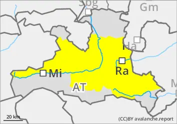
The avalanche risk is moderate. Wet loose snow and slab avalanches are possible in all aspects on slopes below around 2200 metres that have not yet been discharged. The avalanches can occur spontaneously or be triggered by individuals. They usually remain small to medium-sized. Above 2200 m, small slab avalanches can be triggered in fresh wind slab in some places. The number and size of snowdrift accumulations increase slightly with altitude. In a few places above 2200 m, weak layers in the persistent weak layer can also be disturbed by individuals in the extended northern sector; the slabs can reach medium size.
Snowpack
Outgoing longwave radiation at night is limited; a thin crust of melted snow can only form on the snow surface at summit level. With the onset of rain, the snowpack is further soaked up to around 2000 metres. At higher altitudes (from around 2200 m), small-scale snowdrift accumulations form. The fresh wind slab contains soft layers that are temporarily prone to triggering. In addition, on shady slopes from around 2200 m, there are still prone to triggering weak layers of angular shapes and deep rime in the old snowpack.
Tendency
Saturday will bring more sunshine and a slight rise in temperatures. The fresh wind slab sets quickly, the old and wet snow problem remains.
Danger level
Avalanche Problem
Wet snow
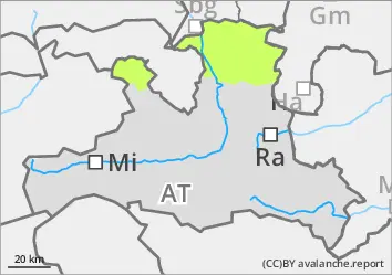
Occasional small wet snow slides
The avalanche risk is low. With the onset of rain, isolated wet avalanches can spontaneously occur from slopes of all aspects that have not yet been discharged. The risk of entrainment and falling should be taken into account.
Snowpack
The snow surface can consolidate somewhat overnight. With light rainfall, however, it softens again during the day and is further moistened. In shady areas above around 2000 metres, there are still faceted layers in the lower part of the snowpack. In general, there is little snow and the snow cover is thinning out.
Tendency
Saturday brings more sunshine again. The soaking is progressing.
Danger level
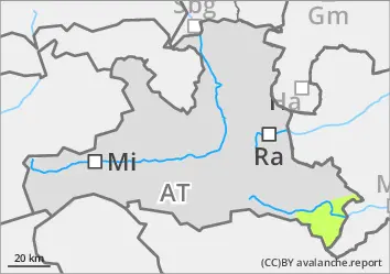
Avalanche Problem
Wet snow
Wind slab
1800m
Some fresh wind slab snow in the summit areas and occasional small wet snow slides
The avalanche risk is low. With the arrival of rain, small wet snow slides may spontaneously occur from slopes of all aspects that have not yet been discharged. In addition, small-scale snowdrift accumulations will form in the summit areas with some new fallen snow and wind, which are temporarily prone to triggering. Slab avalanches in fresh wind slab remain small.
Snowpack
Outgoing longwave radiation at night is limited and the snow surface hardly crusts can form. With the onset of rain, the snowpack below around 1800 metres is further soaked. In the summit areas, small-scale snowdrift accumulations form on the existing, moist snowpack. Soft layers in the fresh wind slab are temporarily prone to triggering.
Tendency
Saturday will bring more sunshine and a slight rise in temperatures. The fresh wind slab settles quickly.