Danger level
 | 1800m |
|  |
|  | ||||
| |
|  |


![]()
Blown snow
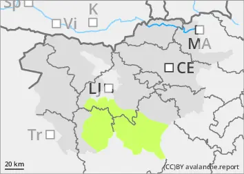
New fallen snow and blowing snow are the main dangers. The snowpack stability is reduced, especially on slopes and in ravines, where the snow thickness is greater due to snow accumulations. In addition to new fallen snow, weak layers in the snowpack deeper in the snowpack can be a local problem. These weak layers are more common in the axis above the forest. In particular, a medium-sized avalanche can be triggered by a large load exceeding the load-bearing capacity of these layers.
Snowpack
dp.4: cold following warm / warm following cold
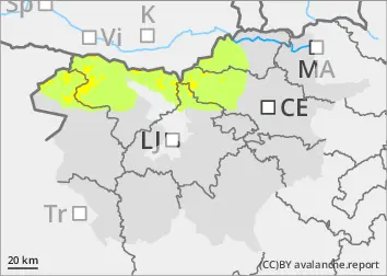
The last snowfall was accompanied by a strong northerly wind, which blew the snow down to the old base in many places and created snowdrift accumulations in the leeward areas. In some places, these are on top of a layer of Graupel, which is a potentially dangerous Weak layer. Locally, the layers of Graupel are 5-10 cm thick, possibly more. In the old snow cover, the snow layers are mostly well interconnected. Deep below the surface, several weak layers of faceted snow crystals and sheared grains occur, which are more frequent on axial slopes.
Tendency
Sunday will be sunny and even warmer. The avalanche danger will remain similar, with the possibility of some small to medium wet snow avalanches on prominent Sunny slopes over the weekend. If the night on Monday is cloudy, the frequency of wet avalanches on Monday will be higher than over the weekend.