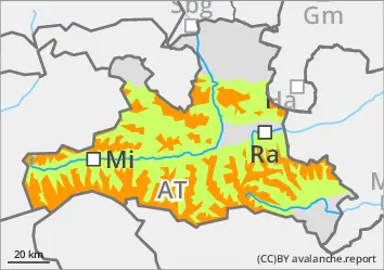
Avalanche prone locations partially covered in wind slab snow
The avalanche risk is INCREDIBLE above the tree line. New fallen snow and extensive snowdrift accumulations are very easy to disturb in some places. All aspects are affected, both adjacent to ridgelines and far from ridgelines. Snow slabs can be medium, in the higher elevations (especially on western, northern and eastern slopes) also large. In some places, the last, calmer snowfall has covered the wind slab and makes it difficult to recognise the danger. Spontaneous loose snow avalanches are to be expected from very sunny steep terrain, at low and medium altitudes also individual gliding avalanches.
Snowpack
Under the influence of strong winds from west to north, 40 to 60 cm of new fallen snow has fallen since Wednesday evening, in some places (for example on the Hochkönig and in places in the Hohe Tauern) even around 80 cm. Breaks are possible both within the new and windslab snow as well as in the old snowpack, in which faceted crystals (sometimes on crusts) weaken the structure both near the surface and deeper inside. On shady slopes (W-N-E) and high in the Alps, avalanches triggered on the surface can also affect deep-lying weak layers.
Tendency
Poor visibility and light snow showers on Sunday. The proneness to triggering in the wind slab is only slowly decreasing.
Danger level
treeline
Avalanche Problem
Wind slab
Treeline
Gliding snow
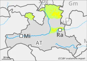
The wind slab is prone to triggering, but sometimes difficult to recognise
The avalanche risk is moderate. Above the tree line, the fresh wind slab can easily be triggered as a snow slab. Avalanches can reach medium size. There are avalanche prone locations adjacent to ridgelines as well as distant from ridgelines, in steep gullies and in forest aisles. The wind slab is partially covered with snow away from areas adjacent to the ridgeline, and the avalanche prone locations are difficult to recognise. Loose snow avalanches are to be expected spontaneously from very sunny steep terrain, and small gliding avalanches are also possible on very steep grassy slopes.
Snowpack
With intermittent strong winds from west to north, 30 cm to 50 cm of new fallen snow has fallen since Wednesday evening. On the sunny slopes, it often lies on previously apery soils, on shady slopes on an old snowpack weakened by angular forms (partly also on crusts) and near the ground (deep rime). Snow slabs break mainly within the fresh wind slab and new snow layers, occasionally also on one of the uppermost weak layers in the persistent weak layer. On very steep meadow slopes, the snow glides along the ground.
Tendency
Poor visibility and light snow showers on Sunday. No significant change.
Danger level
treeline
Avalanche Problem
Wind slab
Treeline
Persistent weak layer
2000m
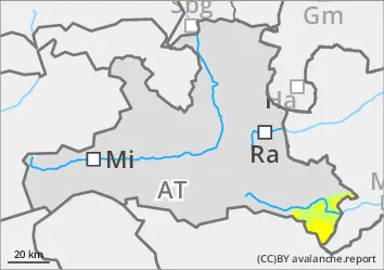
Consistently avoid fresh wind slab!
The avalanche risk is moderate above the tree line. Fresh wind slabs can be triggered as small or medium-sized slabs in all aspects, even under low loads. Avalanche prone locations are mainly in gullies, bowls and behind terrain edges, also distant from ridgelines. Take particular care on very steep western, northern and eastern slopes above around 2000 metres. Transitions from little to more snow are particularly unfavourable.
Snowpack
Stormy north-westerly winds are constantly forming fresh wind slabs. The wind slab is deposited above the tree line on an unfavourable old snow surface. The old snowpack is weak, especially on western, northern and eastern slopes above around 2000 metres, faceted crystals and a floating snow foundation close to the ground weaken the structure.
Tendency
Poor visibility on Sunday, but at most unproductive snow showers. The north-westerly wind picks up again. Wind slab problem unchanged.