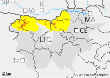
New fallen snow, weak layers still deep in the snowpack
Since Saturday, 10-20 cm of New fallen snow has fallen above altitudes of around 1600 m. It snowed with a moderate south-westerly wind, which built up small snowdrift accumulations on the leeward sides. In addition to the new fallen snow, weak layers in the snowpack deeper in the snowpack are a problem. These weak layers are more numerous in the axis above the forest. In particular, a large avalanche can be triggered if the load exceeds the load-bearing capacity of these layers.
Precipitation will occur in the second half of the day on Monday. The snowfall level will be at an altitude of around 1500 m and 20-30 cm of New fallen snow is expected to fall. The danger of avalanches will increase due to new fallen snow in the high alpine regions. Initially, it will rain in the mid-mountains. The rain will stabilise the snowpack and wet snow avalanches may occur.
Snowpack
dp.1: deep persistent weak layer
In an old snow cover, the layers of snow are mostly well connected, with a Crust on top that mostly supports the skier's weight. Deep below the surface, there are several weak layers of shreds and sheared grains.
Since Saturday, 10-20 cm of new fallen snow has fallen on top of the old snow cover above altitudes of about 1600 m. During the snowfall, some localised freshet may also have fallen, which represents a new Weak layer. On Monday, a further 20-30 cm of New fallen snow is expected to fall in the second half of the day.