The problem is the weak layers in the snowpack, which are deeper in the snowpack. If the load exceeds the load-bearing capacity of the deeper Weak layers, a deep and large avalanche can be triggered. There are many such weak layers, especially on axis above the forest. Small wet snow avalanches are possible during the day on sunny slopes.
Snowpack
dp.1: deep persistent weak layer
In high alpine regions, there is a crust on the surface, and the snow layers are mostly well connected. The Crust supports the skier's weight. In the old snow cover, several weak layers of shreds and sheared grains occur deep below the surface. On Saturday it snowed lightly, with up to 5 cm of New fallen snow.
Tendency
On Monday, it will start snowing. The snowfall level will be around 1700 m and 20-30 cm of New fallen snow may fall. The danger of avalanches will increase.
Danger level
1800m
Avalanche Problem
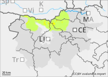
Persistent weak layer
1800m
New snow
1800m
Weak layers persist deep in the snowpack
The problem is the weak layers in the snowpack, which are deeper in the snowpack. If the load exceeds the load-bearing capacity of the deeper Weak layers, a deep and large avalanche can be triggered. There are many such weak layers, especially on axis above the forest. Small wet snow avalanches are possible during the day on sunny slopes.
Snowpack
dp.1: deep persistent weak layer
In high alpine regions, there is a crust on the surface, and the snow layers are mostly interconnected. The crust supports the skier's weight and can be frozen in the morning. In the mid-mountains, more and more terrestrial areas appear on the sunny slopes. In the old snow cover, several weak layers of shreds and frosted grains occur deep below the surface.
Tendency
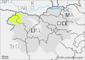
It will clear up on Tuesday. Faster in the high alpine regions than in the mid mountains. There will be no major warming. The danger of avalanches will remain similar.