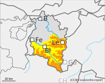
Beware fresh snow, drifts and weak layers on shady slopes: prone to triggering
As a result of fresh snow and winds, avalanche danger is increasing. The fresh snow and freshly generated drifts can easily trigger a medium-sized avalanche by minimum additional loading. Danger zones occur primarily in steep terrain and in wind-loaded gullies and bowls. In addition, avalanches on shady slopes can fracture down to deeper weak layers and in isolated cases then grow to large size. Such danger zones occur especially where the snow is shallow and in transitions from shallow to deep snow. Wherever there is solar radiation, small-to-medium sized loose snow avalanches are possible in steep rocky terrain.
Snowpack
By Sunday morning, 20cm of fresh snow fell in the Arlberg region, up to 25cm in Verwall and Silvretta, locally more. Due to NW winds, fresh snowdrift accumulations were generated. The fresh snow and drifts have often been deposited on a loosely-packed old snowpack surface or atop surface hoar. They are prone to triggering. The mid-level part of the snowpack consists of well-settled, compact layers widespread which on high-altitude shady slopes cover a poorly structured old snowpack fundament.
Tendency
On Monday, snow showers will repeatedly pass through starting at midday, often accompanied by strong-velocity westerly winds. Fresh trigger-sensitive snowdrift accumulations will be generated.
Danger level
2000m
Avalanche Problem
New snow
2000m
New snow
2000m
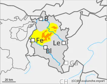
Beware fresh snow, drifts: prone to triggering
The fresh snow and drifts can be triggered as medium-sized avalanches even by minimum additional loading. Danger zones occur primarily in steep terrain and in wind-loaded gullies and bowls. In addition, avalanches on shady slopes can fracture down to deeper weak layers and in isolated cases then grow to large size.
Snowpack
By Sunday morning 25-30cm of fresh snow fell. As a result of NW winds, fresh snowdrift accumulations will be generated. They will be deposited often atop a loosely-packed old snowpack surface or atop surface hoar and are prone to triggering. The mid-level part of the snowpack consists widespread of well settled, compact layers which on shady slopes at higher altitudes blanket a poorly structured old fundament.
Tendency
On Monday, snow showers will repeatedly pass through starting at midday, often accompanied by strong-velocity westerly winds. Fresh trigger-sensitive snowdrift accumulations will be generated.
Danger level
treeline
Avalanche Problem
Wind slab
Treeline
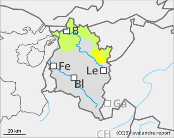
Beware fresh snow, drifts: prone to triggering
Avalanche danger above the timberline is moderate, below that altitude danger is low. The fresh snow and drifts can be triggered even by minimum additional loading as generally small-sized avalanches. Danger zones occur primarily in steep terrain and in wind-loaded gullies and bowls. If avalanches on shady slopes fracture down to deeper layers of the snowpack, they can grow to medium size. Apart from the risks of being buried in snow masses, the danger of being swept along and forced to take a fall also require caution.
Snowpack
By Sunday morning, 15-20cm of fresh snow fell. Due to NW winds, fresh snowdrift accumulations were generated. The fresh snow and drifts have often been deposited on a loosely-packed old snowpack surface or atop surface hoar. They are often prone to triggering. The mid-level part of the snowpack consists of well-settled, compact layers widespread which on high-altitude shady slopes cover a poorly structured old snowpack fundament.
Tendency
On Monday, snow showers will repeatedly pass through starting at midday, often accompanied by strong-velocity westerly winds. Fresh trigger-sensitive snowdrift accumulations will be generated.