On very steep north-facing slopes on the summits, small slab avalanches can be triggered with large additional loads. This is particularly the case at transitions from a little to a lot of snow.
Snowpack
Despite the lack of outgoing longwave radiation, the snowpack will be mostly hard and moist down to the ground in the morning. Some new fallen snow will fall on this largely stable snowpack on Saturday. Only on the shady slopes adjacent to the ridgeline, crest or summit will there be weak layers of faceted crystals at the base of the snowpack. The low altitudes are snowed out.
Tendency
Depending on the amount of new snow, the avalanche risk may increase slightly.
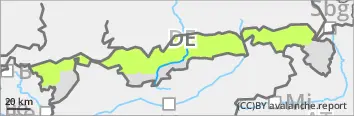
Danger level
2000m
Avalanche Problem
Persistent weak layer
2000m
Persistent weak layers are still problematic in some places.
The avalanche risk is low. Persistent weak layers are the main problem. The few avalanche prone locations are mainly in the northern aspects of the high altitudes on very steep slopes and at the entrance to gullies and bowls. Slab avalanches can be triggered with a large additional load and can reach medium size.
At medium altitudes, individual small to medium-sized gliding avalanches cannot be ruled out on slopes with smooth ground that have not yet been unloaded.
Snowpack
In shady high-altitude areas, layers of faceted crystals can be found deep under a compact snowpack and in some places close to the surface under a thin melt-freeze crust. A few centimetres of new fallen snow will fall on the compact old snow pack during the day changes on Saturday under the influence of wind. At medium elevations, the snowpack is wet towards the ground. The low altitudes are snowed out.
Tendency
Depending on the amount of new snow, the avalanche risk may increase slightly.