Main danger: sliding away and falling atop hard, smooth surfaces and being swept along by small-sized snowdrift slides, particularly on north-facing slopes. Outside of that, winter sports enthusiasts can trigger small-sized loose-snow avalanches on very steep east-to-south-to-west facing slopes. Small-sized loose-snow avalanches can trigger naturally in steep rocky terrain.
Snowpack
Below 1500m heavy rain, above that altitude appx. 10-15cm of fresh snow from region to region. It will be deposited on a hardly frozen, mostly softened up surface, on shady slopes frequently atop surface hoar or a hardened rain crust. No further triggerings in older weak layers of the snowpack have been registered in recent days at the Avalanche Warning Service.
Tendency
On Friday no change expected, as the result of an intermediate high-pressure front.
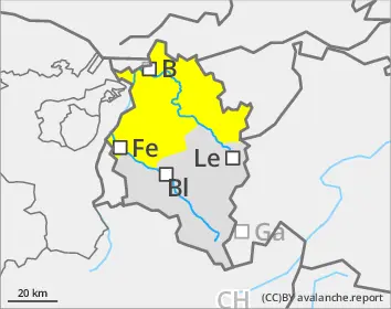
Danger level
2000m
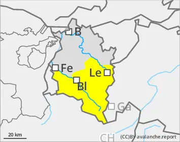
Avalanche Problem
Persistent weak layer
2000m
Wind slab
Treeline
Wet snow
2200m
Wet snow + drifts on shady slopes
Isolated avalanches can still be triggered in the weak old snow by winter sports enthusiasts, particularly in little-skied backcountry terrain where the surface is not capable of bearing loads. Danger zones occur especially in spots where the snow is relatively shallow, and in transitions from shallow to deep snow. Avalanches can trigger down to deeper layers inside the snowpack and grow to large size. Caution urged towards freshly generated snowdrift accumulations, particularly on steep shady slopes they are prone to triggering. On hard-frozen steep slopes, the danger of sliding and falling require special caution. In addition, isolated wet slab avalanches can be triggered in very steep terrain where no melt-freeze crust capable of bearing loads was able to form during the night.
Snowpack
Below 1500m, heavy rain, above that altitude appx. 10cm of fresh snow, somewhat less in Verwall and Silvretta, on sunny slopes deposited atop a barely frozen surface, on shady slopes frequently atop surface hoar and below 2300-2500m atop a very hard rain crust. The middle layer of the snowpack often consists of settled, well consolidated layers which on shady slopes at higher altitudes blanket an old snow fundament with large sized cup-shaped crystals.
Tendency
On Friday no change expected, as the result of an intermediate high-pressure front.