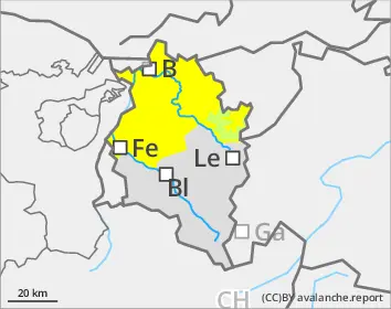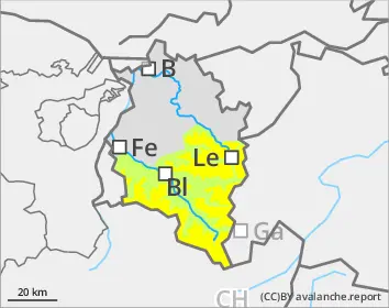
Danger level
 | 2000m |
|  |
|  |

![]()
Generally favorable conditions. Caution urged on steep shady slopes.
Isolated avalanches can still be triggered in the weak old snow by winter sports enthusiasts, particularly in little-skied backcountry terrain where the surface is not capable of bearing loads. Danger zones occur especially in spots where the snow is relatively shallow, and in transitions from shallow to deep snow. Avalanches can trigger down to deeper layers inside the snowpack and grow to large size. A cautious route selection and maintaining safety distances between tourers on ascents and descents are recommended. On hard-frozen steep slopes, the danger of sliding and falling require special caution. During the course of the day, likelihood of naturally triggered small wet-snow avalanches triggering increases somewhat on sunny, steep slopes.
Snowpack
Variably to heavily clouded nighttime skies will reduce the outgoing longwave radiation somewhat. The melt-freeze crust on sunny slopes will then be thinner and will soften earlier in the day than recently. On north-facing slopes the rain crust will extent regionally up to 2300-2500m. The mid-sedtion of the snowpack consists of well-settled, consolidated layers where shady slopes at high altitudes are blanketed over by large-sized cup-shaped crystals.
Tendency
On Thursday a cold front will bring minor amounts of fresh snow. The persistent weak layer problem on shady high-altitude slopes will persist.