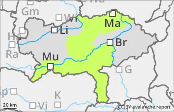
Avalanche Service Styria

Tuesday 10 March 2026

Published 9 Mar 2026, 17:00:00


Danger level

1800m
Avalanche Problem
Persistent weak layer
1800m


Weak persistent layer is still the main problem

The avalanche risk is moderate above 1800 metres and low below. There is still a persistent weak layer problem in the extended northern sector. Medium-sized slab avalanches can still be triggered by people in mainly steep gullies and bowls. The avalanche prone locations are usually difficult to recognise and are often located in transition areas from little to much snow. On the sunny slopes, the softened, barely stabilised snowpack can trigger wet snow avalanches.

Snowpack

Depending on the degree of cloud cover overnight and the wind influence of the last few hours, a surface crust of varying thickness can form, which softens during the day on the sunny slopes and the snowpack becomes increasingly damp or wet. On shady slopes at higher altitudes there are still areas with a soft (faceted) snow surface, but often the layer is already hard here too. Below this, there are still responsive weak layers in the form of faceted crystals in the area of crusts or frost that is still snowed in. In addition, the foundation consisting of floating snow (deep rime) continues to weaken the snowpack (partly also on the south side). Medium (sunny slopes) and low altitudes are largely free of snow.

Tendency

Weak disturbances on Wednesday, with some precipitation in places, it will remain mild. No significant change in the avalanche risk is expected.


Danger level

1800m
Avalanche Problem
Persistent weak layer
1800m


Note the persistent weak layer problem in the extended northern sector!

The avalanche risk is low. Nevertheless, there is still a persistent weak layer problem in the extended northern sector. Occasionally, mainly in very steep gullies and bowls, slab avalanches can be triggered by people. The avalanche prone locations are usually difficult to recognise and are often located in transition areas from a little to a lot of snow. On the sunny slopes, the softened, barely stabilised snowpack can trigger small wet snow avalanches.

Snowpack

Depending on the degree of cloud cover overnight and the wind influence of the last few hours, at least a thin melt-freeze crust will form, which will soften during the daytime changes on the sunny side. The snowpack will become increasingly damp or wet here. On the shady slopes, there are still areas with a soft (faceted) snow surface at higher altitudes, but the layer is often already hard here too. Below this, there are still weak layers of large faceted crystals in the lower part of the snowpack, especially close to the ground. Medium (sunny slopes) and low altitudes are largely free of snow.

Tendency

Weak disturbances on Wednesday, with some precipitation in places, it will remain mild. No significant change in the avalanche risk is expected.