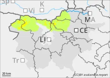
With a slight cooling and cloudy weather, the danger of wet snow avalanches has decreased.
However, there are still some places in the high alpine regions with blown snow where a heavy load can trigger avalanches. Weak layers in the snowpack are also a problem. If the load exceeds the load-bearing capacity of the deeper Weak layers, a deep and large avalanche can be triggered. There are many such weak layers, especially on axis above the forest.
Snowpack
dp.1: deep persistent weak layer dp.10: springtime scenario
The snowpack freezes at night, but becomes harder during the day, especially on Sunny slopes. This process will be less pronounced today. In high alpine regions, the snowpack will remain frosty during the day.
The old snow cover is made up of layers of bonded snow that are already somewhat compacted and mostly well interconnected. In the old snow cover, several weak layers of faceted snow crystals and frosted grains occur deep below the surface.
Tendency
It will clear up on Tuesday. Faster in the high alpine regions than in the mid mountains. There will be no major warming. The danger of avalanches will remain similar.