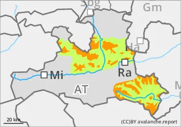
Moisture penetrates into poor persistent weak layers
The avalanche risk is low at low altitudes in the morning and rises rapidly to level 3 everywhere due to heat and radiation. In addition, from the tree line onwards, especially medium, but sometimes also large dry slab avalanches can easily be triggered by individuals in some places (even from a distance). All aspects are affected, but increasingly the north-east sector. Danger areas are difficult to recognise away from obvious pillows of wind drifted snow, which is why caution and a defensive choice of route is still advised. This applies in particular in the area of the tree line and in forest aisles. As the snowpack softens, spontaneous wet loose snow and gliding avalanches are to be expected on the sunny slopes, in low to medium altitudes also in the northern sector. It is also possible for skiers to release wet snow slabs. Loose snow slides can easily tear through the drift and persistent weak layer and reach dangerous sizes.
Snowpack
The upper part of the snowpack is made up of several slab thicknesses of new fallen snow from the last week, which was influenced by the wind. Especially at the beginning, snow fell with less wind and at colder temperatures, which is why soft layers are also embedded. These overlay even older wind slab snow, which in turn lies on an unfavourable base of faceted crystals and deep rime. Fractures primarily occur between the last snow packs, but can also penetrate through to the old snow foundation, which is usually completely transformed. During the night, a mostly stable melt cover forms, which softens quickly during the day with the warmth. In places with little snow, the snowpack is already approaching isothermal conditions.
Tendency
Only a slow decline in the risk due to poor old snow cover.
EARLIER Danger level
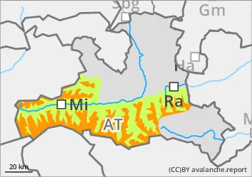
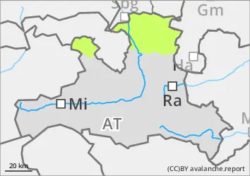
treeline
Avalanche Problem
Persistent weak layer
Treeline
Wet snow
2200m
LATER Danger level
treeline
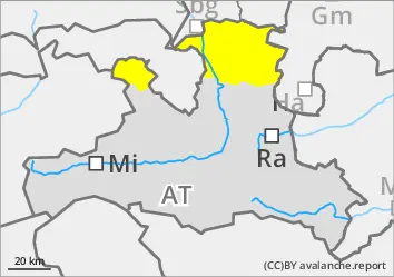
Avalanche Problem
Persistent weak layer
Treeline
Wet snow
2200m
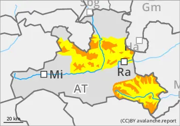
Moisture penetrates into poor persistent weak layers
The avalanche risk is considerable above the tree line. Below this, it is low in the morning and quickly increases to moderate danger everywhere due to heat and radiation. Above the tree line, medium and sometimes large dry slab avalanches can easily be triggered by people in some places. All aspects are affected, but increasingly the north-east sector. Danger areas are difficult to recognise away from obvious pillows of wind drifted snow, which is why caution and a defensive choice of route is still advised. This applies in particular in the area of the tree line and in forest aisles. As the snowpack softens, spontaneous wet loose snow and gliding avalanches are to be expected on the sunny slopes, including in the northern sector at low to medium elevations. It is also possible for skiers to release wet snow slabs. Loose snow slides can easily tear through the drift and persistent weak layer and reach dangerous sizes.
Snowpack
The upper part of the snowpack is made up of several layers of new fallen snow from the last week, which was influenced by the wind. Where there was a significant old snowpack before the snowfall, the foundation has been completely transformed and is cohesionless. Fractures primarily occur between the last snow packs, but can penetrate through to this deep snow pack under greater load. During the night, a mostly stable melt cover forms, which softens quickly during the day with the heat. In some places, isothermal conditions are already reached.
Tendency
Only a slow decline in the risk due to poor old snow cover.
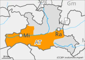
EARLIER Danger level
Avalanche Problem
Wet snow
Persistent weak layer
1500m
LATER Danger level
Avalanche Problem
Wet snow
Persistent weak layer
1500m
Moisture penetrates into poor persistent weak layers
The avalanche risk is considerable from the tree line upwards and moderate below. At low and medium altitudes, warmth and rainfall put a strain on the snowpack, while fresh wind slab is formed at higher altitudes. Medium to large slab avalanches can be triggered by individuals in some places. Danger areas are located at the transition from little to more snow and generally next to blown-off areas as well as in the entrance areas to gullies and bowls filled with wind slabs. Caution should also be exercised at the edge of forests and in forest aisles. At low and medium elevations, small, wet loose snow and gliding avalanches are to be expected.
Snowpack
Around 20 - 30 cm of heavy new fallen snow lies on top of the previously moistened snowpack. At high altitudes, there is an inhomogeneous and prone to triggering sequence of drifting snow layers underneath due to changing wind speeds. Where present, the old snow foundation has been completely transformed. Fractures are possible mainly between the last layers of drift snow, but deeper-lying faceted layers in the persistent weak layer or the coarse-grained base of deep rime are also affected. At low elevations, the snowpack is completely soaked and in some places isothermal conditions are reached.
Tendency
Heavy precipitation sets in again, with intense rain at times up to around 2000 metres on Tuesday. Above that, there is heavy new fallen snow of 30 to 60 cm (mainly Steinberge/Hochkönig/Tennengebirge). The avalanche situation worsens again.