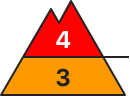
Highly prone to triggering wind slab snow at the top, spontaneous wet snow avalanches at the bottom
The avalanche risk is high above the tree line (level 4) and considerable below. Individual naturally triggered avalanches are still possible and in many places medium and sometimes large slab avalanches can easily be triggered by individuals (even from a distance). All aspects are affected, but increasingly north and east-facing steep terrain. Danger areas are not easy to recognise everywhere, which is why caution and a defensive choice of route is still advised. This applies in particular in the area of the tree line and in forest aisles. Wet loose snow and gliding avalanches are possible at low and medium altitudes due to heavy rainfall. These usually remain medium-sized, but occasionally the entire snowpack can slide off on very steep, unstructured terrain.
Snowpack
Up to half a metre of fresh new or wind slab snow lies on top of several more thick layers of wind-blown new fallen snow from the last few days. Especially at the beginning, snow fell with less wind and at colder temperatures, which is why soft layers are also embedded. These overlay somewhat older wind slab snow, which in turn lies on an unfavourable base of faceted crystals and deep rime. In wind-protected areas, some surface hoar has also been snowed in. Up to around 1800 metres, the snowpack was soaked by heavy rain. Fractures primarily occur between the last snow packs, but can also penetrate through to the old snow foundation, which is usually completely transformed. At low and medium altitudes, heat and rainfall put a strain on the snowpack.
Tendency
Precipitation will set in again, with rain falling at times up to around 2000 metres on Tuesday. Above that, 20 to 40 cm will fall. The avalanche situation remains tense.
Danger level
2000m
Avalanche Problem
Persistent weak layer
2000m
Wind slab
2000m
Wet snow
2000m
Naturally triggered avalanches still expected
Dangerous avalanche situation persists apart from heavily skied terrain
Large amounts of fresh snow and drifts from last week blanket a weak old snowpack. Avalanches can easily be triggered by one single winter sports enthusiast in all aspects, especially in little-skied terrain. Danger zones increase with ascending altitude, occur widespread in terrain near to and distant from ridgelines. Caution urged in transitions from shallow to deep snow, for example, at entries into gullies and bowls. Remote triggerings are possible. Avalanches can be large-sized and plummet over flattish passages. As a result of renewed rainfall and the snowpack becoming ever wetter, wet slab avalanches can be expected at low and intermediate altitudes. If these fracture to deeper down layers of the snowpack, they can in isolated cases grow to large size. On steep grass-covered slopes, glide-snow avalanches can trigger. Zones with glide cracks should under all circumstances be avoided.
Snowpack
During the night there was 20mm of rainfall registered in the northern regions of highest precipitation. During the daytime, another 10mm can be added to that. Above 2000m, about 15 cm of fresh snow, accompanied by strong-velocity winds. The large amounts of fresh snow from the last few days have been repeatedly transported in varying directions, snowdrift accumulations are poorly bonded with the old snowpack. Weak layers are widely prevalent in the lower part of the snowpack. The extraordinary avalanche activity last week confirms just how prone to triggering the weak layer is. This layer persists apart from heavily skied zones and in starting zones which have not yet discharged. At low and intermediate altitudes the snowpack is thoroughly wet. Even at higher altitudes there are breakable crusts, particularly in areas exposed to the sun.
Tendency
Avalanche danger is gradually diminishing, but the situation for winter sports enthusiasts remains extremely treacherous in little-skied terrain
Danger level
treeline
Avalanche Problem
Wind slab
Treeline
Wet snow
1600m
Avalanche prone locations due to easily triggered wind slabs and naturally triggered avalanches!
Above the tree line there is still a considerable avalanche risk, below it is moderate. Above the tree line in particular, there are prone-to-triggering drift snow packs that can occur in all aspects. Medium to sometimes large slab avalanches can be triggered by even a small additional load. Steep terrain should therefore be avoided. Avalanche prone locations are mainly adjacent to ridgelines, but also distant from ridgelines, at terrain transitions and in the entrance areas of bowls and gullies. Remote triggering cannot be ruled out. In transition areas where there is too little snow, weak layers in foundations (persistent weak layer problem) could be addressed. Below the snowfall level, spontaneous damp to wet small to medium loose snow avalanches from undischarged steep terrain are to be expected. Above the tree line there is still a considerable avalanche risk, below it is moderate. Above the tree line in particular, there are prone-to-triggering drift snow packs that can occur in all aspects. Medium to sometimes large slab avalanches can be triggered by even a small additional load. Steep terrain should therefore be avoided. Avalanche prone locations are mainly adjacent to ridgelines, but also distant from ridgelines, at terrain transitions and in the entrance areas of bowls and gullies. Remote triggering cannot be ruled out. In transition areas where there is too little snow, weak layers in foundations (persistent weak layer problem) could be addressed. Below the snowfall level, spontaneous damp to wet small to medium loose snow avalanches from undischarged steep terrain are to be expected.
Snowpack
With the unstable weather, snowfall of varying intensity and strong to stormy winds from changing directions, extensive snowdrift accumulations have formed, which contain weak layers, do not bond well with the old snowpack and lie on a weak foundation. At high altitudes, the snow base, fundament still contains faceted crystals without binding, especially on the north and shady slopes, and partly floating snow. Up to the middle elevations, the snowpack was at least superficially moist due to rain, below that it is soaked to wet.
Tendency
Snowfall again with strong to stormy winds, fresh wind slab above the tree line and rain in some places up to mid-altitude. The avalanche situation remains precarious.
Danger level
1800m
Avalanche Problem
Wind slab
1800m
Persistent weak layer
1800m
Wet snow
1400m
Increase in avalanche danger to level 4!
The avalanche danger is assessed as high (level 4) from 1800 metres upwards. During the intense precipitation in combination with storms (transport!), spontaneous discharges are expected at high altitudes. At lower elevations, spontaneous wet snow avalanches and gliding avalanches on steep meadow slopes are to be expected. Exposed transportation routes may be affected.
In the touring area, it is difficult to assess the avalanche situation in the prevailing weather conditions. Slab avalanches can be triggered on many steep slopes with little additional load.
Snowpack
New fallen snow and strong winds from the west to northwest have led to extensive transported snow and in some cases massive snowdrift accumulations in the aspects from northeast to east to south in the past few days. In addition, 30 to 50 cm of new fallen snow is expected in stormy conditions. The connection between the wind slab and the old snowpack will not be sufficient. There are still weak layers in the transition to the persistent weak layer. In the shady areas, the snowpack is weakened by faceted crystals and floating snow.
Tendency
High pressure influence and massive warming at altitude from Wednesday lunchtime. The zero-degree level will rise to 3000 metres by Wednesday evening. The high avalanche risk remains.
Danger level
2000m
Avalanche Problem
New snow
2000m
New snow
2000m
Wet snow
1800m
Avalanches release themselves.
The avalanche risk is high above 2000 metres and considerable below that. The main problem is the predicted new fallen snow. Many self-triggering dry slab avalanches are to be expected due to the additional load of the new fallen snow. These can become large at high altitudes. In addition, individual winter sports enthusiasts can trigger avalanches, especially on steep slopes where the snow is bonded by wind. From extremely steep, rocky terrain, the new fallen snow is released in the form of loose snow avalanches.
Wet snow is also problematic. Due to the rainfall, gliding avalanches can be expected from very steep terrain with a smooth surface at medium altitudes and wet loose snow avalanches from steep terrain interspersed with rocks. Wet snow avalanches are to be expected on all slopes that have not yet been discharged up to approx. 1800 m and can reach medium size. Open snow mouths indicate avalanche prone locations. Exposed transportation routes can be hit by wet avalanches.
Snowpack
Snowdrift accumulations can be found in all aspects. At higher altitudes, they often lie on graupel, old surface hoar, soft intermediate layers or in the area of thin crusts on faceted crystals. Above 1800 m, there are weak layers of faceted crystals in the snowpack on shady slopes. Up to around 1800 m, the snowpack becomes soaked through rainfall. At medium altitudes, the base of the snowpack is usually wet.
Tendency
The avalanche situation remains tense.
Danger level
1800m
Avalanche Problem
Wet snow
1800m
Wind slab
1600m
Wet snow problem at the bottom, wind slab problem at the top
The avalanche risk is considerable. The main problem is wet snow. Below 1800 m, gliding avalanches on steep slopes with smooth ground, such as on mountain meadows, in gappy deciduous forests or on rock slabs, release themselves. Staying in areas below glide cracks should be avoided. Wet loose snow avalanches release on slopes that have not yet been discharged, especially in extremely steep terrain. Wet avalanches can reach medium size and hit exposed transportation routes.
In addition, wind slabs above 1600 m must be taken into account. Medium-sized slab avalanches can be triggered on steep slopes of all aspects by low additional loads.
Snowpack
Snow falls at higher altitudes with a changing snow line. At medium altitudes, it mainly rains. Here the snowpack is particularly moist on the south side and in the forest down to the ground, below 1500 metres it is completely soaked. With strong westerly winds, the new fallen snow at higher elevations will be extensively transported and will be deposited prone to triggering on the already thick drift snow packs of the last few days. In places, these are lying on graupel or old surface hoar. Above 1800 m, weak layers of faceted crystals can be found on shady slopes at the base of the snowpack.
Tendency
The avalanche situation remains tense.
Danger level
treeline
Avalanche Problem
Wind slab
Treeline
Persistent weak layer
Treeline
Wet snow
1800m
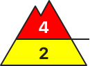
High prone to triggering in wind slabs
The avalanche risk is high above the tree line (level 4) and moderate below. Individual naturally triggered avalanches are still possible and in many places medium and sometimes large slab avalanches can easily be triggered by individuals (even from a distance). All aspects are affected, but increasingly north and east-facing steep terrain. Danger areas are not easy to recognise everywhere, which is why caution and a defensive choice of route is still advised. This applies in particular in the area of the tree line and in forest aisles. Wet loose snow and gliding avalanches are possible at low and medium altitudes. These usually remain medium-sized at most, but occasionally the entire snowpack can slide off on very steep, unstructured terrain.
Snowpack
Up to half a metre of fresh new or wind slab snow lies on top of several more thick layers of wind-blown new fallen snow from the last few days. Especially at the beginning, snow fell with less wind and at colder temperatures, which is why soft layers are also embedded. These overlay somewhat older wind slab snow, which in turn lies on an unfavourable base of faceted crystals and deep rime. In wind-protected areas, some surface hoar has also been snowed in. Up to around 1800 metres, the snowpack was at least superficially moistened. Fractures primarily occur between the last snow packs, but can also penetrate through to the old snow foundation, which is usually completely transformed. At low and medium altitudes, heat and rainfall put a strain on the snowpack.
Tendency
Precipitation will set in again, with rain falling at times up to around 2000 metres on Tuesday. Above that, 20 to 40 cm will fall. The avalanche situation remains tense.
Danger level
2000m
Avalanche Problem
Wet snow
2000m
Wind slab
2000m
Persistent weak layer
1800m
Rainfall leading to wet-snow avalanches
Due to heavy rain impact, increasingly frequent medium-sized wet-snow avalanches can be expected in steep terrain. Where there is lots of snow on the ground, these releases can grow to large size. On steep grass-covered slopes, glide-snow avalanches can occur. Zones with glide cracks on the surface should under all circumstances be avoided. At high altitudes, avalanches can be triggered even by one single winter sports enthusiasts, particular from freshly generated snowdrift accumulations. Danger zones occur in steep ridgeline terrain and behind abrupt changes in the terrain. Particularly on very steep shady slopes above 1800m, avalanches can fracture down to deeper-down layers inside the snowpack and then grow to large size. Whumpf noises and fractures which appear when treading upon the snowpack are alarm signals.
Snowpack
About 20mm of rain was registered during the nocturnal hours. During the daytime another 15mm can be added to that. Above 2000m, about 15cm of fresh snow, accompanied by strong-velocity winds. At high altitudes, fresh and older snowdrift accumulations in all aspects are only moderately to poorly bonded with the generally weak old snowpac. On shady slopes there are weak layers in the lower part of the snowpack.
Tendency
Wet-snow activity will decrease when the precipitation ceases. Then a high-pressure front will diminish avalanche danger also at high altitudes.
Danger level
treeline
Avalanche Problem
Wind slab
Treeline
Wet snow
1600m
Considerable avalanche danger!
The avalanche danger is predominantly categorised as considerable. Due to some intense snowfall and wind, there will be additional wind slab avalanches in the higher elevations. The triggering of medium to rarely large slab avalanches is possible to likely on some steep slopes due to low additional loads. Due to the local old snow problem, the snowpack can tear through to deeper layers. Above the tree line, medium to sometimes large spontaneous slab avalanches are possible. Spontaneous wet snow avalanches are to be expected below the snowfall level due to heavy rainfall.
Snowpack
With the unstable weather, snowfall of varying intensity and strong to stormy winds from changing directions, extensive snowdrift accumulations have formed, which contain weak layers, do not bond well with the old snowpack and lie on a weak foundation. At high altitudes, the snow base, fundament still contains faceted crystals without binding, especially on the north and shady slopes, and partly floating snow. Up to the middle elevations, the snowpack was at least superficially moist due to rain, below that it is soaked to wet.
Tendency
Snowfall again with strong to stormy winds, fresh wind slab above the tree line and rain in some places up to mid-altitude. The avalanche situation remains precarious.
Danger level
treeline
Avalanche Problem
Wind slab
Treeline
Persistent weak layer
Treeline
Wet snow
1800m
Prone to triggering wind slab snow at the top, spontaneous wet snow avalanches at the bottom
The avalanche risk is considerable. At low and medium altitudes, warmth and heavy rainfall put a strain on the snowpack, while fresh wind slab is formed at higher altitudes. Medium to large slab avalanches can be triggered in some places by a single person. Danger areas are located at the transition from little to more snow and generally next to blown-off areas as well as in the entrance areas to gullies and bowls filled with wind slabs. Caution should also be exercised at the edge of forests and in forest aisles. At low and medium elevations, medium wet loose snow and gliding avalanches are also to be expected.
Snowpack
Rainfall has soaked the snowpack up to altitudes of around 1800 metres. At high altitudes, the new snow cover is inhomogeneous and prone to triggering (harder layers alternate with softer ones) due to repeated wind influences of varying intensity. Where present, the old snow foundation has been completely transformed. Fractures are possible mainly between the last layers of drift snow, but under greater stress, deep-lying faceted layers in the persistent weak layer or the coarse-grained base of deep rime are also affected.
Tendency
Heavy precipitation sets in again, with intense rain at times up to around 2000 metres on Tuesday. Above that, there is heavy new fallen snow of 30 to 60 cm (mainly Steinberge/Hochkönig/Tennengebirge). The avalanche situation worsens again.
Danger level
1800m
Avalanche Problem
Wet snow
1800m
Wind slab
Treeline
Persistent weak layer
1700m
As the weather warms up, the danger of wet snow avalanches has increased. Blowing snow in the high alpine regions!
On Monday, as the weather warmed up, wet snow avalanches and gliding avalanches broke out, mainly on sunny slopes and in the mid-mountains. This danger will decrease slightly temporarily. However, there are still a number of places in the high alpine regions with blowing snow where a small load can trigger a major avalanche. Weak layers in the snowpack are also a problem. If the load exceeds the load-bearing capacity of the deeper Weak layers, a deep and large avalanche can be triggered. There are many such weak layers, especially on axis above the forest.
Snowpack
dp.1: deep persistent weak layer dp.4: cold following warm / warm following cold
The old snow cover is made up of layers of bonded snow that are already somewhat compacted, and which are mostly well connected to each other. Deep below the surface, several weak layers of faceted snow crystals and coarse grains occur in the old snow cover.
This base was covered by 50 to 80 cm of new fallen snow during the last snowfall in the high alpine regions, which has already begun to settle to some extent. The warmer temperatures and sunshine have led to the formation of a more or less distinct Crust. The snow is drying out during the day and freezing at night. The snowpack is also melting in the mid-mountains. This process will be less pronounced on Tuesday due to cloudier weather.
Tendency
It will clear up by Wednesday morning. The snowpack will also frost over the central mountains. Wednesday will be sunny and quite warm. The zero isotherm will rise above 2500 m above altitudes in the afternoon. The danger of Avalanches will increase due to the daily thaw.
Danger level
treeline
Avalanche Problem
Wind slab
Treeline
Wind slab
Treeline
Wet snow
1300m
Prone to triggering wind slab snow in the higher elevations! Beginning of wet snow problems at lower altitudes.
The avalanche risk above the tree line is rated as "considerable". Stormy north-westerly winds create fresh drift snow packs in the east and south sectors, which in many places can be triggered by individual winter sports enthusiasts as medium slab avalanches. Spontaneous wet snow avalanches and smaller gliding avalanches can occur at lower altitudes.
Snowpack
The connection between the drift snow layer and the old snowpack is often insufficient. Prone to triggering weak layers in the form of snow deposits of varying hardness also exist in the bound layer in places. In shady high altitudes, the old snowpack is unfavourably structured in places with crusts and embedded faceted crystals.
With increasing moisture penetration, the snowpack at lower altitudes increasingly loses firmness and stability and can also start to glide snow on steep grass and forest slopes.
Tendency
High pressure influence and massive warming at high altitude from midday on Wednesday. The zero-degree level will rise towards 3000 metres in the evening. The wet snow problem is a priority at all altitudes and will increase briefly!
Danger level
treeline
Avalanche Problem
Wind slab
Treeline
Persistent weak layer
Treeline
Wet snow
1800m
Highly prone to triggering windslab snow on poor old snowpack
The avalanche risk is considerable from the tree line upwards and moderate below. At low and medium altitudes, warmth and rainfall put a strain on the snowpack, while fresh wind slab is formed at higher altitudes. Medium to large slab avalanches can be triggered by individuals in some places. Danger areas are located at the transition from little to more snow and generally next to blown-off areas as well as in the entrance areas to gullies and bowls filled with wind slabs. Caution should also be exercised at the edge of forests and in forest aisles. At low and medium elevations, small, wet loose snow and gliding avalanches are to be expected.
Snowpack
Rainfall has moistened the snowpack at least on the surface up to altitudes of around 2000 metres, and at lower altitudes it is sometimes wet right down to the ground. At high altitudes, the new snow cover is inhomogeneous and prone to triggering (harder layers alternate with softer ones) due to repeated wind influences of varying intensity. Where present, the old snow foundation has been completely transformed. Fractures are possible mainly between the last layers of drifting snow, but deeper-lying faceted layers in the persistent weak layer or the coarse-grained base of deep rime are also affected.
Tendency
Heavy precipitation sets in again, with intense rain at times up to around 2000 metres on Tuesday. Above that, there is heavy new fallen snow of 30 to 60 cm (mainly Steinberge/Hochkönig/Tennengebirge). The avalanche situation worsens again.
Danger level
treeline
Avalanche Problem
Wind slab
Treeline
Wet snow
Treeline
Prone to triggering wind slab snow in the higher elevations! Beginning of wet snow problems at lower altitudes.
The avalanche danger is assessed as considerable. Drifting snow - persistent stormy north-westerly winds form fresh wind slabs that are prone to triggering. The north, east and south sectors are particularly affected. In some places, medium-sized slab avalanches can be triggered by individual winter sports enthusiasts. However, spontaneous slab avalanches are also to be expected. Spontaneous wet snow avalanches and smaller gliding avalanches can occur at lower and medium altitudes, including on steep forest slopes or embankments.
Snowpack
The connection between the drift snow packs and the old snowpack is sometimes insufficient. At shady high altitudes, the old snowpack is unfavourably structured in places with crusts and embedded angular crystals. With increasing moisture penetration, the snowpack loses stability at lower altitudes and can also start to glide snow on steep grass and forest slopes.
Tendency
The weather will deteriorate again on Tuesday night, with heavy rain and snowfall starting again after midnight at the latest. Above around 1000 metres, a good 10 to 20 cm of new fallen snow is possible by midday on Tuesday. It will remain stormy! The risk of avalanches is increasing!
Danger level
Avalanche Problem
Persistent weak layer
Wind slab
Moderate avalanche danger. Fresh wind slab!
The avalanche danger is rated as moderate. Particular caution is required behind terrain edges and in entrances to gullies and bowls. Medium-sized and occasionally large slab avalanches can be triggered by individuals in some places. Spontaneous wet snow avalanches are to be expected at lower altitudes and gliding avalanches on steep meadow slopes.
Snowpack
Fresh wind slab snow overlays older wind slab snow! In the aspects from north-east to east to south, there are still older snowdrift accumulations lying on a weak layer of surface hoar or faceted crystals. The snow base, fundament is weakened by faceted crystals and floating snow. At lower elevations, the snow becomes moist and loses firmness. On steep meadow slopes, the snow can begin to glide.
Tendency
High pressure influence and massive warming at altitude from Wednesday lunchtime. The zero-degree level will rise to 3000 metres by Wednesday evening. Wet snow avalanches will be an issue on Wednesday!
Danger level
Avalanche Problem
Wet snow
Wind slab
1000m
Wet snow problems at lower altitudes. Occasional prone to triggering wind slab in the higher elevations!
The avalanche risk is moderate (level 2). Spontaneous wet snow avalanches and smaller gliding avalanches can occur in steep slope zones, including forest slopes or on embankments. Due to persistent stormy north-westerly winds, isolated fresh drift snow packs are prone to triggering. Especially in the north-east to south-east sectors, slab avalanches can be triggered in a few places by individual winter sports enthusiasts.
Snowpack
With increasing moisture penetration, the snowpack loses stability at lower elevations and can also start to glide snow on steep grass and forest slopes. The connection between fresh snow packs and the old snowpack is sometimes insufficient. In shady high altitudes, the old snowpack with faceted crystals is unfavourably structured in places.
Tendency
With the influence of high pressure and a strong rise in temperatures on Wednesday, the wet snow problem will increase!
Danger level
Avalanche Problem
Wet snow
Gliding snow
Rainfall leading to wet loose-snow avalanches
Wet loose-snow avalanches of medium size can be expected in very steep terrain. On steep grass-covered slopes, glide-snow avalanches can release. Zones with glide cracks on the surface should under all circumstances be avoided.
Snowpack
Where there is snow on the ground, it is thoroughly wet.
Tendency
Wet-snow activity will end when the precipitation ceases. Then, when high-pressure weather conditions set it, the ground will become further bare of snow.
Danger level
treeline
Avalanche Problem
Wind slab
Treeline
Wet snow
Treeline
More new fallen snow than expected! Beware of prone to triggering wind slabs at higher elevations!
The avalanche risk is considerable above the tree line. New fallen snow and stormy winds create avalanche prone locations in the form of fresh wind slabs. These continue to grow with persistent stormy north-westerly winds, especially at higher altitudes. In some places, especially in steep entrance areas, gullies and bowls, these can already be triggered by individual winter sports enthusiasts as slab avalanches.
At lower altitudes, spontaneous wet snow slides from very steep areas and smaller gliding avalanches cannot be ruled out with rain.
Snowpack
Stormy north-westerly winds and up to 25 cm of new fallen snow are increasingly forming fresh snowdrift accumulations. The connection between the drift snow packs and the old snowpack is insufficient in places. Prone to triggering weak layers in the form of snow deposits of varying hardness also exist in places in the bound layer. In shady high altitudes, the old snowpack is unfavourably structured in places with crusts and embedded faceted crystals.
With increasing moisture penetration, the snowpack loses stability at lower altitudes and can also start to glide snow on steep grass and forest slopes.
Tendency
High pressure influence and massive warming at high altitude from midday on Wednesday. The zero-degree level will rise towards 3000 metres in the evening. The wet snow problem is a priority at all altitudes and will increase briefly!
Danger level
1300m
Avalanche Problem
Wet snow
1300m
Gliding snow
1300m
Minor wet snow avalanches possible due to thawing
The snowpack of the last snowfall has become unstable as the weather warms up. The danger of wet snow avalanches has increased, especially on extreme terrain. On grassy slopes, gliding avalanches will be possible. This only applies to the highest peaks where there is some more snow.
Snowpack
dp.4: cold following warm / warm following cold
As the weather warms up, much of the snow from the last snowfall has been cleared away. The snow line is at around 1200 m. At higher altitudes, the snow of the last snowfall has become much heavier and is being transformed more quickly.
Tendency
Typical spring conditions are expected over the next few days.
The snowpack will freeze overnight, but during the day, with sunshine and high temperatures, the snow will change and melt more quickly.
Danger level
1400m
Avalanche Problem
Wind slab
1400m
Wet snow
1400m
Prone to triggering wind slab snow in the higher elevations! Beginning of wet snow problems at lower altitudes.
The avalanche danger is rated as "moderate" above the tree line. Stormy north-westerly winds create fresh drift snow packs, which in some places can be triggered by individual winter sports enthusiasts as medium slab avalanches. Spontaneous wet snow slides and smaller gliding avalanches can occur at lower elevations.
Snowpack
Stormy north-westerly winds and some new fallen snow are increasingly forming fresh snowdrift accumulations. The connection between the drift snow packs and the old snowpack is insufficient in places. Prone to triggering weak layers in the form of snow deposits of varying hardness also exist in places in the bound layer. In shady high altitudes, the old snowpack is unfavourably structured in places with crusts and embedded faceted crystals.
With increasing moisture penetration, the snowpack loses stability at lower altitudes and can also start to glide snow on steep grass and forest slopes.
Tendency
With the influence of high pressure and a strong rise in temperatures on Wednesday, the wet snow problem will increase!
Danger level
1500m
Avalanche Problem
Wind slab
1500m
Persistent weak layer
1500m
Fresh wind slab!
The avalanche danger is assessed as moderate above 1500 metres. The avalanche prone locations are in the north and east sectors. Fresh wind slabs can easily be triggered by an alpinist.
Snowpack
Fresh wind slab is deposited on a wet or moist snowpack. The connection between the two layers will not be sufficient.
Tendency
High pressure influence and massive warming at altitude from Wednesday lunchtime. The zero-degree level will rise to 3000 metres by Wednesday evening. Isolated wet snow slides are possible on Wednesday.
Danger level
800m
Avalanche Problem
Wet snow
800m
Wet snow avalanche possible due to thawing
The snowpack of the last snowfall has become unstable as it warms up. The danger of wet snow avalanches has increased, especially on extreme terrain. On grassy slopes, gliding avalanches will be possible.
Snowpack
dp.4: cold following warm / warm following cold
As the weather warms up, the snowpack from the last snowfall is rapidly melting.
Tendency
Typical spring conditions are expected over the next few days.
The snowpack will freeze overnight, but during the day, with sunshine and high temperatures, the snow will change and melt more quickly.
Danger level
Avalanche Problem
Wet snow
Wet snow problem with rain
The avalanche risk is moderate (level 2). Spontaneous wet snow avalanches and smaller gliding avalanches can occur in steep slope zones, including forest slopes or on embankments. Due to persistent stormy north-westerly winds, isolated fresh drift snow packs are prone to triggering. Especially in the north-east to south-east sectors, slab avalanches can be triggered in a few places by individual winter sports enthusiasts.
Snowpack
With increasing moisture penetration, the snowpack loses stability at lower elevations and can also start to glide snow on steep grass and forest slopes. The connection between fresh snow packs and the old snowpack is sometimes insufficient. In shady high altitudes, the old snowpack with faceted crystals is unfavourably structured in places.
Tendency
With the influence of high pressure and a strong rise in temperatures on Wednesday, the wet snow problem will continue!