The current snowpack pattern is uncommon and requires special attention and caution!
New fallen snow in the high alpine regions, weak layers in the old snow cover.
Snow will fall in the high alpine regions during the day, with southerly winds spreading new fallen snow and building up larger snowdrift accumulations. Spontaneous avalanches will occur. In the current conditions, we advise against visiting the high alpine regions!
Areas of blowing snow are more dangerous and can trigger a major Avalanche. New fallen snow will put additional load on the old snow cover. This may exceed the load-bearing capacity of the deeper Weak layers and trigger a deep and large avalanche. Such weak layers are abundant, especially in the axis above the forest, but are not excluded elsewhere.
In parts of the mid-mountains where it rains, the rain will wet and labyrinth the snowpack. Wet snow avalanches and gliding avalanches may occur.
Snowpack
dp.1: deep persistent weak layer dp.4: cold following warm / warm following cold
At the end of last week, there were a few centimetres to 20 cm of New fallen snow above an altitude of around 1400 m. The old snow cover is made up of layers of bonded snow that are already somewhat compacted. Deep below the surface, the Old snow cover contains several weak layers of shreds and coarse grains.
This base will receive 60-80 cm of new fallen snow in the high alpine regions on Thursday, with snowfall intensifying in the middle of the day. The snow line will be between 1000 m and 1500 m, rising during the day.
Tendency
Snow conditions will remain challenging in the coming days.
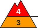
Danger level
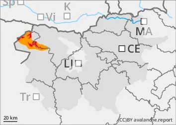
1700m
Avalanche Problem
New snow
1700m
Persistent weak layer
1700m
Wind slab
1700m
Wet snow
1700m
The current snowpack pattern is uncommon and requires special attention and caution!
New fallen snow in the high alpine regions, weak layers in the old snowpack.
Snow will fall in the high alpine regions during the day, with southerly winds spreading new fallen snow and building up larger snowdrift accumulations. Spontaneous avalanches are possible. Conditions are challenging and avalanche danger will increase during the day!
Areas of blowing snow are more dangerous, where a major Avalanche may be triggered. New fallen snow will put additional load on the old snow cover. This may exceed the load-bearing capacity of deeper Weak layers and trigger a deep and large avalanche. Such weak layers are abundant, especially in the axis above the forest, but are not excluded elsewhere.
In parts of the mid-mountains where it rains, the rain will wet and labyrinth the snowpack. Wet snow avalanches and gliding avalanches may occur.
Snowpack
dp.1: deep persistent weak layer dp.4: cold following warm / warm following cold
At the end of last week, there were a few centimetres to 10 cm of New fallen snow above an altitude of around 1400 m. The old snow cover is made up of layers of bonded snow that are already somewhat compacted. Deep below the surface, the Old snow cover contains several weak layers of shreds and coarse grains.
This base will receive 30-50 cm of new fallen snow in the high alpine regions on Thursday, with snowfall intensifying in the afternoon. The snow line will be between 1000 m and 1500 m, rising during the day.
Tendency
Snow will continue on Thursday evening and into Friday night. The danger of avalanches will increase.
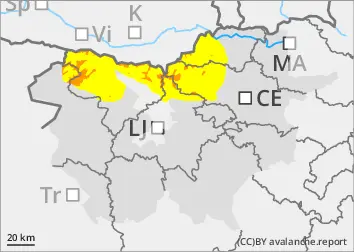
Danger level
1200m
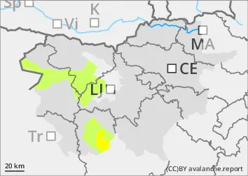
Avalanche Problem
Gliding snow
1200m
Wet snow
1200m
Increased amount of new snow in the highest parts of the mid-mountains, snowdrift accumulations
Wet snow avalanches and gliding avalanches.
Showers will occur during the day, with rain mainly outside the highest peaks. The rain will wet and labyrinth the snowpack. Wet snow avalanches and gliding avalanches may occur.
Snowpack
The old snow cover is made up of layers of bonded snow that are already somewhat compacted and mostly well connected. A depth hoar has formed at the interface between the snowpack and the ground.