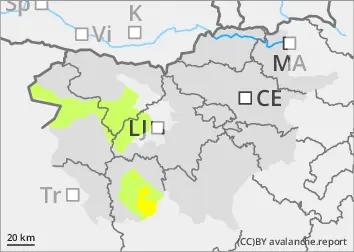
Danger level
 | 1700m |
|  |
|  | ||||
| |
|  |


![]()
The current snowpack pattern is uncommon and requires special attention and caution!
New fallen snow in the high alpine regions, weak layers persist.
In particular, even a small additional load can trigger a small avalanche on snowdrift accumulations. A triggered avalanche or an otherwise large Additional load may exceed the load-bearing capacity of the deep hard layers, triggering a deep and widespread (large) avalanche. Such weak layers are particularly abundant in the axis above the forest, but are not excluded elsewhere. Gliding avalanches also occur on steep smooth slopes.
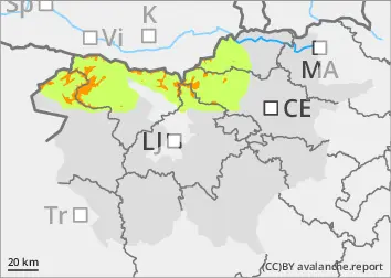
Snowpack
dp.1: deep persistent weak layer
dp.4: cold following warm / warm following cold
At the end of last week, there was up to 20 cm of New fallen snow above an altitude of around 1400 m. Above 1700 m the snow fell on the hard surface of the old snow cover, below that on a breakable crust or soft ground. A strong nor'easter on Sunday morning built up new small snow drifts which did not connect well with the frozen ground. The old snow cover is made up of layers of bonded snow that have already melted a little. Deep below the surface, the old snow cover contains several weak layers of shreds and coarse grains.
Tendency
On Thursday, it will snow and the danger of avalanches will increase due to new fallen snow and blowing snow.