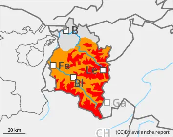
Intensive precipitation and storm-strength winds are leading to high avalanche danger. Avalanches can easily be triggered by one single winter sports enthusiast or be triggered naturally. Exposed areas can be placed at risk. Danger zones occur on steep slopes near to and distant from ridgelines, behind drops in the landscape and in wind-loaded gullies and bowls. Frequency and spread of avalanche prone locations increase with ascending altitude. Whumpf noises and fractures which appear when treading upon the snowpack, as well as freshly released avalanches are alarm signals. Activities in outlying terrain demand restraint. The inexperienced should not leave secured ski runs.
Snowpack
By Tuesday evening, 30-50cm of fresh snow was registered. During the daytime the snowfall continued. Storm-strength westerly-to-northwesterly winds transported the snow, generate fresh snowdrift accumulations. Fresh snow and drifts often lie deposited on top of graupel, in wind-protected terrain also atop surface hoar or on thin, trigger-sensitive melt-freeze layers. Also older snowdrifts and the weak snowpack will be blanketed by fresh snowfall.
Tendency
As precipitation tapers off, danger of naturally triggered avalanches will gradually diminish. Situation remains treacherous for winter sports enthusiasts.
Danger level
Avalanche Problem
New snow
Caution urged in wind-exposed steep terrain
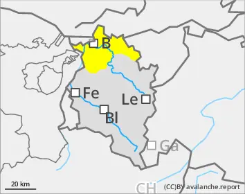
Avalanche danger is moderate above the timberline, often at that level at the timberline. Fresh snow and drifts can easily be triggered as small-to-medium sized avalanches by one single winter sports enthusiast. Danger zones occur especially behind drops in the landscape and in wind-loaded gullies and bowls.
Snowpack
By Tuesday evening, approximately 20cm of fresh snow is expected. Stormy westerly to northwesterly winds will transport the snow, generate fresh snowdrift accumulations, particularly above the timberline.