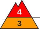
Avalanche danger will increase significantly as a result of intensive precipitation and storm-strength winds, reaching during morning hours Danger Level 4 (“high”) above 2000m. Snowdrift accumulations can easily be triggered by one single winter sports enthusiast in all aspects. Danger zones occur in steep terrain near to and distant from ridgelines, behind drops in the terrain, and in wind-loaded gullies and bowls. Frequency and spread of avalanche prone locations increase with ascending altitude and during the course of the day. Starting in the morning, increasingly frequent naturally triggered avalanches can be expected. The danger is focused in particular on alpine terrain for snow sports. Triggered avalanches, moreover, can fracture down to deeper layers inside the snowpack and thereby grow to large size. Whump noises and fractures appearing on the surface when treading on it, as well as freshly released avalanches, are alarm signals. Activitiers in outlying terrain demand restraint. The inexperienced should not leave secured ski runs.
Snowpack
Overnight there was 15-20cm of fresh snow registered. During the daytime an additional 20cm is anticipated, in the Arlberg and Verwall up to 40cm additionally. The storm-strength westerly-to-northwesterly winds will massively transport the loosely-packed snow and generate far-reaching, trigger-sensitive snowdrift accumulations. The fresh and older drifts frequently lie deposited atop graupel, in wind-protected zones atop surface hoar or on trigger-sensitive, shallow melt-freeze encrusted layers. Also still trigger-sensitive older snowdrift accumulations and a weak old snowpack with marked weak layers will be blanketed with fresh snowfall.
Tendency
On Tuesday avalanche danger will increase within the same danger level as a result of further snowfall
Danger level
treeline
Avalanche Problem
Wind slab
Treeline
Wind slab
Treeline
Persistent weak layer
1800m
Significant increase in avalanche danger
Avalanche danger will increase significantly as a result of intensive precipitation and storm-strength winds, reaching during morning hours Danger Level 4 (“high”) above 2000m. Snowdrift accumulations can easily be triggered by one single winter sports enthusiast in all aspects. Danger zones occur in steep terrain near to and distant from ridgelines, behind drops in the terrain, and in wind-loaded gullies and bowls. Frequency and spread of avalanche prone locations increase with ascending altitude and during the course of the day. Starting in the morning, increasingly frequent naturally triggered avalanches can be expected. The danger is focused in particular on alpine terrain for snow sports. Triggered avalanches, moreover, can fracture down to deeper layers inside the snowpack and thereby grow to large size. Whump noises and fractures appearing on the surface when treading on it, as well as freshly released avalanches, are alarm signals. Activitiers in outlying terrain demand restraint. The inexperienced should not leave secured ski runs.
Snowpack
Overnight there was 10-15cm of fresh snow registered. During the daytime an additional 20cm is anticipated, in the Arlberg and Verwall up to 40cm additionally. The storm-strength westerly-to-northwesterly winds will massively transport the loosely-packed snow and generate far-reaching, trigger-sensitive snowdrift accumulations. The fresh and older drifts frequently lie deposited atop graupel, in wind-protected zones atop surface hoar or on trigger-sensitive, shallow melt-freeze encrusted layers. Also still trigger-sensitive older snowdrift accumulations and a weak old snowpack with marked weak layers will be blanketed with fresh snowfall.
Tendency
On Tuesday avalanche danger will increase as a result of further snowfall
Danger level
1600m
Avalanche Problem
Wind slab
1600m
Wind slab
1600m
Persistent weak layer
1800m
Cold front brings new fallen snow and storms
The avalanche risk is considerable above 1600 metres and moderate below that. The main problem at all altitudes is wind slab avalanches. Slab avalanches can easily be triggered by individual winter sports enthusiasts. Avalanche prone locations can be found on steep slopes laden with drifting snow in the north-west, north to south aspects, behind slope discontinuities and in gullies and bowls, as well as in forest aisles and clearings. They increase in number and size with altitude. Avalanches reach medium size.
Above 1800 m, avalanches on very steep shady slopes can also tear through to deeper weak layers in the old snowpack.
Snowpack
Snow is falling under strong storm conditions from westerly directions and is deposited as wind slab snow on the soft snow surface. Some of the fresh snowdrift accumulations are thick and very prone to triggering. In the upper part of the old snowpack, layers of graupel, surface hoar or thin wind and melt-freeze crusts prone to triggering are embedded in places. Above 1800 m, on shady slopes, there are deeper weak layers of faceted crystals in the snowpack.
Tendency
The avalanche situation will remain tense throughout the week.
Danger level
1700m
Avalanche Problem
Persistent weak layer
1700m
Wind slab
1700m
The current snowpack pattern is uncommon and requires special attention and caution!
New fallen snow in the high alpine regions, weak layers persist.
In particular, even a small additional load can trigger a small avalanche on snowdrift accumulations. A triggered avalanche or an otherwise large Additional load may exceed the load-bearing capacity of the deep hard layers, triggering a deep and widespread (large) avalanche. Such weak layers are particularly abundant in the axis above the forest, but are not excluded elsewhere. Gliding avalanches also occur on steep smooth slopes.
Snowpack
dp.1: deep persistent weak layer dp.4: cold following warm / warm following cold
In the last 3 days, several centimetres of New fallen snow have fallen above an altitude of around 1400 m, locally up to 20 cm. Above 1700 m the snow fell on the hard surface of the Old snow cover, lower down on breakable crust or soft ground. A strong nor'easter on Sunday morning built up new small snow drifts which did not connect well with the frozen ground.
The old snow cover is made up of layers of bonded snow that have already melted a little. Deep below the surface, the old snow cover contains several weak layers of shreds and coarse grains.
Tendency
The danger of avalanches will remain similar.
Danger level
treeline
Avalanche Problem
Wind slab
Treeline
Persistent weak layer
Treeline
New fallen snow and wind slabs increase the avalanche danger!
The avalanche danger increases rapidly with altitude and is rated as considerable above approx. 1800 metres. The avalanche situation remains very delicate for alpinists. The persistent weak layer problem is still present and difficult to assess. In addition, fresh wind slab leads to an increase in avalanche danger. The avalanche prone locations are from north-west to east in terrain adjacent to ridgelines and at the entrances to gullies and bowls. Medium-sized slab avalanches can be triggered by individuals. It is very likely that avalanches will tear through to deeper layers.
Snowpack
Fresh wind slab overlays soft layers of faceted crystals and surface hoar. The persistent weak layer is weakened by the kinetic metamorphism. The wind slab falls cold and is brittle.
Tendency
Strong to stormy westerly winds will blow across the northern side of the Alps on Monday night as a warm front passes through. A few centimetres of new fallen snow may fall in the northern Limestone Alps. In the evening and during the night to Tuesday, a north-westerly weather pattern will set in, which will lead to renewed snowfall in the northern foothills. The considerable risk of avalanches remains.
Danger level
1800m
Avalanche Problem
Persistent weak layer
1800m
Wind slab
Treeline
Tours require restraint, observe multiple starting zones
The avalanche risk is considerable above 1800 metres and low below. The situation remains precarious for winter sports.
On slopes of all aspects, medium-sized slab avalanches can easily be triggered by individuals in some places. There is a high likelihood that surface-triggered avalanches will tear through to deeper layers. In particular on north-west to north to east-facing slopes above 1800 metres. Danger areas are sometimes barely recognisable and require a defensive choice of route. Take particular care near transitions from little to much snow, behind terrain edges and in the entrance areas to steep gullies and bowls. Remote triggering is possible, and naturally triggered avalanches can occasionally occur.
Snowpack
Around 10 cm of new fallen snow falls over the course of the daytime changes. Fresh and older wind slab snow overlaid with soft layers of faceted crystals and deep frost. In areas protected from the wind, on shady slopes above around 2000 m and on sunny slopes above 2400 m, surface hoar has also been snowed in in places. Fractures occur either in soft layers near the surface or around the crust that forms the transition to the completely angular old snowpack. In general, areas with little snow alternate with sometimes considerable snowdrift accumulations in a confined space with overall snow depths that are well below average.
Tendency
As the snowfall continues, snowdrift accumulations grow.
Danger level
treeline
Avalanche Problem
Wind slab
Treeline
Persistent weak layer
1800m
It is essential to pay attention to fresh loads prone to triggering and the persistent weak layer problem!
The avalanche risk is considerable in some areas above the tree line. In some areas in the eastern sector and on the south side, there are more extensive avalanches that can be triggered as medium slab avalanches in filled steep slopes and in steep bowls and gullies even with a small additional load. It is difficult to recognise individual avalanche prone locations due to the persistent weak layer problem in northern to eastern steep slopes. Here, snow slabs can also be triggered by individuals. This applies to both drift and persistent weak layers.
Snowpack
Around 20 cm of new fallen snow may fall overnight. Strong winds from the northwest will form fresh, prone-to-triggering drifts that will bond poorly with the old snowpack. At higher elevations, the old snowpack remains largely unchanged with thin melt-freeze crusts and faceted crystals near the ground on the north and shady slopes, some of which are floating snow. The snowpack is still very unevenly distributed, even at higher altitudes there is only a little snow, often the new fallen snow falls on apery ground.
Tendency
No significant change. Pay attention to wind slabs
Danger level
treeline
Avalanche Problem
Wind slab
Treeline
Persistent weak layer
Treeline
Pay attention to fresh, prone to triggering wind slab.
Above the tree line, there is still a moderate avalanche risk (level 2). The strong westerly wind is transporting the soft new fallen snow and forming fresh snowdrift accumulations, especially in the north to east to south aspects, adjacent to ridgelines and in steep gullies and bowls. These can be triggered by individual winter sports enthusiasts as slab avalanches, especially in the transition from a little to a lot of snow. There is still a persistent weak layer problem on shady slopes at high altitudes. Avalanches can occasionally tear through angular weak layers, but usually remain small.
Snowpack
Above around 1000 metres there is about 10 cm of new fallen snow, which was transported by strong north-westerly winds. Fresh drift snow packs are lying on decomposed snow or older drift snow layers and are prone to triggering in places. Underneath, the old snowpack is unfavourably structured in places with crusts and faceted crystals. There are weak layers both at the transitions to the wind slab and within the old snowpack.
Tendency
The avalanche danger remains the same.
In the night to Monday, strong to stormy westerly winds will develop with the passage of a warm front. On Monday, it will snow intermittently in the morning and the clouds will soften at times in the afternoon. In the evening and on Tuesday night, a north-westerly weather pattern sets in, leading to more snowfall.
Danger level
treeline
Avalanche Problem
Wind slab
Treeline
Persistent weak layer
1800m
Prone to triggering and the persistent weak layer problem must be taken into account!
The avalanche risk is moderate above the tree line. In some areas, there are prone-to-triggering avalanches in the eastern sector and on the south side, which can be triggered as small to medium slab avalanches in filled-in steep slopes as well as in steep bowls and gullies with little additional load. As the wind shifts to the south, north-facing slopes are also blown in. Hardly recognisable individual avalanche prone locations due to the persistent weak layer problem are present in northern to eastern steep slopes. Here, snow slabs can also be triggered by individuals. This can occur both as drifting snow and in persistent weak layers.
Snowpack
Around 20 cm of new fallen snow may fall overnight. Strong winds from the northwest will form fresh, prone-to-triggering drifts that will bond poorly with the old snowpack. At higher elevations, the old snowpack remains largely unchanged with thin melt-freeze crusts and faceted crystals near the ground on the north and shady slopes, some of which are floating snow. The snowpack is still very unevenly distributed, even at higher altitudes there is only a little snow, often the new fallen snow falls on apery ground.
Tendency
No significant change. Pay attention to wind slabs
Danger level
1600m
Avalanche Problem
Wind slab
1600m
Wind slab
1600m
Blown-in areas should be avoided.
The avalanche risk is moderate above 1600 metres and low below that. The main problem at all altitudes is wind slab avalanches. Slab avalanches can easily be triggered by individual winter sports enthusiasts. Avalanche prone locations can be found on steep slopes adjacent to ridgelines in the north-west, north to south aspects, behind slope discontinuities and in gullies and bowls, as well as in forest aisles and clearings. Avalanches usually remain small, but if they tear through to deeper weak layers, they can reach medium size.
Snowpack
Accompanied by strong winds from westerly directions, some snow is falling and depositing as wind slab on the soft snow surface. The fresh snowdrift accumulations are very prone to triggering in places. Layers of surface hoar or thin wind and melt-freeze crusts prone to triggering are embedded in the upper part of the old snowpack. On shady slopes, deeper layers of faceted crystals have been preserved in the snowpack in places. Ground contact is to be expected in areas without an old snowpack foundation.
Tendency
Further increase in avalanche danger over the course of the week.
Danger level
1800m
Avalanche Problem
Persistent weak layer
1800m
Wind slab
Treeline
Fresh wind slab snow overlays persistent weak layer problem
The avalanche risk is moderate above 1800 metres and low below. Especially in the sectors from north-west to north to south-east, slab avalanches can be triggered by individuals in some places. Avalanches in wind slabs usually remain small. Avalanches that are triggered in persistent weak layers in deep weak layers or tear through these weak layers can reach medium size. Be careful in particular near transitions from little to more snow and in the blown-in entrance areas to steep gullies. Avalanche prone locations are sometimes difficult to recognise and require a defensive route choice. In areas bordering on the "considerable" avalanche prone location, avalanches are more frequent and can become larger.
Snowpack
Around 5 cm of new fallen snow during the daytime changes. This and the snow from the previous days will be transported extensively. Within the snowpack, bonded snow overlays soft, angular layers. In wind-protected, shady areas above around 2000 m, surface hoar has also been snowed in in places. Fractures occur either in soft layers near the surface or around the crust that forms the transition to the completely built-up old snow foundation. In general, areas with little snow alternate with sometimes considerable snowdrift accumulations in a confined space, with overall snow depths well below average.
Tendency
With some new fallen snow and wind, fresh snowdrift accumulations continue to form.
Danger level
treeline
Avalanche Problem
Persistent weak layer
Treeline
Wind slab
Fresh wind slab!
The avalanche risk is still moderate above around 1900 metres and low below. There is still a persistent weak layer problem. In addition, fresh wind slab is to be expected! The avalanche prone locations are limited but still difficult to recognise. The avalanche prone locations are mainly on north to east facing slopes above 1900 metres. Older wind slab snow is in the northern sector, fresh wind slab snow in the eastern sector. Slab avalanches can be triggered by individuals in a few places here. The slab can tear through to the layer close to the ground.
Snowpack
The persistent weak layer problem still exists. Surface hoar, angular forms or a hard old snowpack have been covered. In the northern and eastern exposures, the old snowpack continues to be weakened by crusts and layers with faceted crystals and floating snow.
Tendency
Strong to stormy westerly winds will blow across the northern side of the Alps on Monday night as a warm front passes through. A few centimetres of new fallen snow may fall in the northern Limestone Alps. Monday will be mostly free of precipitation during the day and the clouds will soften on the southern side of the Alps. In the evening and during the night on Tuesday, a north-westerly weather pattern will set in, resulting in renewed snowfall in the northern foothills. No significant change in the avalanche risk is expected.
Danger level
treeline
Avalanche Problem
Wind slab
Treeline
Persistent weak layer
2000m
Fresh and snow-covered wind slabs are prone to triggering
The avalanche risk is moderate above the tree line and low below. In north-west to north to south-facing slopes, avalanches can be triggered by individuals in some places. Above 2000 metres, slab avalanches are also possible in persistent weak layers in a few places. Occasionally, avalanches can reach medium size. Danger areas are located at the transition from little to more snow and generally next to blown-off areas as well as in the entrance areas to gullies and bowls filled with wind slabs. Caution in the area of terrain traps.
Snowpack
During the daytime changes, up to 15 cm of new fallen snow will fall, which will be transported extensively. Fresh, prone to triggering snowdrift accumulations form, older snowdrift accumulations are covered with snow. On shady slopes protected from the wind above around 2000 metres, surface hoar has also been covered with snow in places. At high altitudes, especially in northern and eastern aspects, bonded snow overlays a weak old snowpack of faceted crystals and deep frost.
Tendency
As the snowfall continues, snowdrift accumulations grow.
Danger level
1200m
Avalanche Problem
Gliding snow
1200m
Increased amount of new snow in the highest parts of the mid-mountains, snowdrift accumulations
Blowing snow, gliding avalanches.
In particular, even a small additional load can trigger a small avalanche on snowdrift accumulations. Gliding avalanches also occur on steep, smooth slopes.
Snowpack
The old snow cover is made up of layers of bonded snow that are already somewhat compacted and mostly well connected. A depth hoar has formed at the interface between the snowpack and the ground.
Tendency
The danger of avalanches will remain similar.
Danger level
1800m
Avalanche Problem
Persistent weak layer
1800m
Wind slab
Treeline
Beware of fresh and snow-covered wind slabs in combination with persistent weak layers
The avalanche risk is moderate above 1800 m and low below.
On slopes of all aspects, medium-sized slab avalanches can be triggered by individuals in some places. Surface-triggered avalanches can tear through to deeper layers. In particular on north-west to north to east-facing slopes above 1800 metres. Danger areas increase with altitude, some of them are barely recognisable and require a defensive choice of route. Take particular care near transitions from little to much snow, behind terrain edges and in the entrance areas to steep gullies and bowls. Cracks when stepping on the snowpack indicate danger.
Snowpack
During the daytime changes, up to 15 cm of new fallen snow falls, which is extensively transported. Fresh and older, over-snowed wind slabs overlay soft layers of faceted crystals and deep frost. In wind-protected, shady areas above around 2000 m, surface hoar has also been snowed in to some extent. Fractures occur either in soft layers near the surface or around the crust that forms the transition to the completely angular old snowpack. In general, areas with little snow alternate with sometimes considerable snowdrift accumulations in a confined space with overall snow depths that are well below average.
Tendency
As the snowfall continues, snowdrift accumulations grow.
Danger level
1500m
Avalanche Problem
Wind slab
1500m
Low avalanche danger, watch out for fresh pillows of wind drifted snow at high altitudes.
At high altitudes, there are sometimes considerable snowdrift accumulations in steep gullies and bowls. These are prone to triggering, especially in the transition from a little to a lot of snow. Tearing through weak layers of old snow is possible, but avalanches remain small. The risk of tearing and falling outweighs the risk of burial. Hardness or icy surfaces can be covered by little new fallen snow and be difficult to recognise.
Snowpack
The snow conditions are below average for mid-February. At high altitudes, there is a considerable amount of wind slab snow in places in gullies and bowls. The small amount of new fallen snow from the last few days has also been transported. The snow thickness is decreasing rapidly in areas distant from ridgelines. Above 1500 m, thin pillows of wind drifted snow can be found in northern and eastern exposures, while windward areas are often icy and snow-poor. Below 1500 m, a thin snowpack has formed on mostly bare ground.
Tendency
The avalanche risk remains low.
The clouds will thicken in the night to Tuesday. A north-westerly current will lead to new fallen snow under the influence of strong winds, with the most snow again falling in the Ybbstal Alps. In the morning, precipitation-free phases will predominate and sunny clear spells will occur on the eastern edge of the Alps. Later, the next snow and sleet showers will spread from the west.
Danger level
treeline
Avalanche Problem
Persistent weak layer
Treeline
Wind slab
Low avalanche danger, but persistent weak layer problems in the northern and eastern exposures!
The avalanche risk is low. In the northern and eastern exposures, there is still a persistent weak layer problem at altitudes above the tree line. In steep terrain, avalanches can be triggered in a few places. Fresh wind slab snow is deposited in the Hochschwab area and can also be triggered as a snow slab. However, even if the old snowpack is torn through, the avalanches usually remain small.
Snowpack
Some new fallen snow covers surface hoar or angular shapes on the north side. The foundation is still weak.
Tendency
Strong to stormy westerly winds will blow across the northern side of the Alps on Monday night as a warm front passes through. A few centimetres of new fallen snow may fall in the northern Limestone Alps. Monday will be mostly free of precipitation during the day and the clouds will soften on the southern side of the Alps. In the evening and during the night on Tuesday, a north-westerly weather pattern will set in, resulting in renewed snowfall in the northern foothills. No significant change in the avalanche risk is expected.
Danger level
Avalanche Problem
Persistent weak layer
Little new fallen snow.
Low avalanche danger.
The avalanche risk is low. Small slab avalanches can be triggered in extremely steep gullies and bowls in isolated places at high altitudes.
Snowpack
There is still little snow. The snowpack is damp or crusted can form in places. In the higher elevations, angular snow crystals continue to weaken the stability on shady slopes.
Tendency
The north-westerly weather conditions will continue on Tuesday. There will be no precipitation on the southern side of the Alps. The wind will remain strong to stormy. No significant change in the avalanche danger.