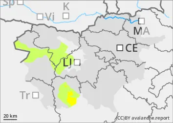
Danger level
 | 1800m |
|  |
|  | ||||
| |
|  |


![]()
The current snowpack pattern is uncommon and requires special attention and caution!
New fallen snow in the high alpine regions, weak layers persist.
In particular, even a small additional load can trigger a small avalanche on snowdrift accumulations. A triggered avalanche or an otherwise large Additional load may exceed the load-bearing capacity of the deep hard layers, triggering a deep and widespread (large) avalanche. Such weak layers are particularly abundant in the axis above the forest, but are not excluded elsewhere. Gliding avalanches also occur on steep smooth slopes.
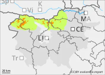
Snowpack
dp.1: deep persistent weak layer
dp.4: cold following warm / warm following cold
In the last 24 hours, several centimetres of New fallen snow have fallen above an altitude of around 1400 metres. Above 1700 m, snow fell on the hard surface of the old snowpack, while lower down it fell on breakable crust or soft ground. The old snow cover is made up of layers of bonded snow that are already somewhat compacted. The cohesion of the layers of blown snow in snowdrift accumulations built up by southerly winds during the snowfall is weaker. In the old snow cover, there are several weak layers of shreds and sheared grains deep below the surface.
Tendency
On Monday night it will become cloudy again, with a westerly breeze. Showers are possible during the day. The danger of avalanches will remain similar.