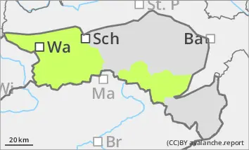
Low avalanche danger, fresh wind slab in the high altitudes
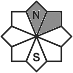
The avalanche risk is low. Fresh, thin pillows of wind drifted snow lie in the aspects from north to east, particularly in terrain adjacent to ridgelines, in the entrance areas of steep gullies and bowls and behind terrain edges. Individual winter sports enthusiasts can trigger small slab avalanches here. In addition, there is still a persistent weak layer problem on shady slopes at high altitudes. Avalanches that are triggered in the wind slab can occasionally tear through the persistent weak layer, but remain small. In general, the risk of entrainment, falling and injury outweighs the risk of burial. Hardness or icy surfaces may currently be covered by little snow and therefore difficult to recognise.
Snowpack
There is still little snow. A few centimetres of new or wind slab snow is lying on a snow surface that is wet or crusted can form right up to the summit areas. In the higher elevations, however, angular snow crystals are still weakening the stability on shady slopes.
Tendency
No change in avalanche danger for the time being. On Saturday, clouds will predominate from the morning and the first light precipitation will set in from midday. The precipitation will only intensify towards the evening.