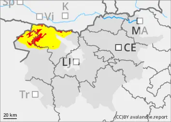
The current snowpack pattern is uncommon and requires special attention and caution!
Large amount of new snow, snowdrift accumulations and a weak layer in the old snow cover.
In the mountains, a significant amount of new snow has fallen over the last two days above an altitude of around 1500 m. Lower down, it has snowed partly (wetter snow) and rained partly. More dangerous are the places where south winds have built up large snow drifts. In shaded areas, there is a weak layer deep in the snowpack.
Spontaneous avalanches are still possible, possibly larger ones. Gliding avalanches are possible. In the current conditions, we advise against visiting the high alpine regions!
Snowpack
dp.1: deep persistent weak layer dp.4: cold following warm / warm following cold
The weak snowpack of previous snowfalls has received a greater amount of snow, and the new snow is poorly bonded to the old base. In the last two-day snow episode, 70-100 cm of New fallen snow fell in the high alpine regions, possibly more than one metre. South winds have built up new large drifts on the leeward sides of ridges. Deep and persistent weak layers are present in the old snow cover. The snowpack is unstable.
Tendency
Conditions will remain challenging in the days ahead.
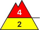
Danger level
1500m
Avalanche Problem
New snow
1500m
Wind slab
Treeline
Persistent weak layer
Treeline
New snow
1500m
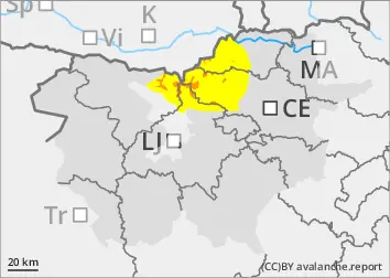
The current snowpack pattern is uncommon and requires special attention and caution!
New fallen snow, blowing snow and weak layers in the snowpack in the high alpine regions
In the mountains, a significant amount of new snow has fallen over the last two days above an altitude of around 1500 m. Lower down, it has snowed partly (wetter snow) and rained partly. More dangerous are the places where south winds have built up large snow drifts. Spontaneous avalanches will occur. Gliding avalanches are possible. Current conditions in the mountains are challenging.
Snowpack
dp.1: deep persistent weak layer dp.4: cold following warm / warm following cold
The weak snowpack of previous snowfalls has received a greater amount of snow, and the new snow is poorly bonded to the old base. During the last two-day snow episode, around 50 cm of new fallen snow fell in the high alpine regions, possibly more locally. South winds have built up new large drifts on the leeward sides of ridges. Deep and persistent weak layers are present in the old snow cover. The snowpack is unstable in many places.
Tendency
Conditions will remain challenging in the days ahead.
Danger level
1500m
Avalanche Problem
New snow
1500m
Wind slab
1500m
Wet snow
1500m
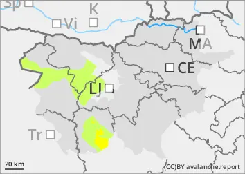
Increased amount of new snow in the highest parts of the mid-mountains, snowdrift accumulations
More new fallen snow and snowdrift accumulations in the highest parts of the Central Mountains
In the mountains, a significant amount of new snow has fallen over the last two days above an altitude of around 1500 m. Lower down, it has snowed partly (wetter snow) and rained partly. Winds from the south and south-east have built up snow drifts on the leeward sides, which can be a danger.
Snowpack
The old snow cover, which was mostly sparse, received 50-60 cm of New fallen snow above an altitude of around 1500 m, and more locally, especially in the south of the country. Winds from the south and south-east have built up drifts on the leeward sides of ridges.
Tendency
The situation in the coming days will remain similar.