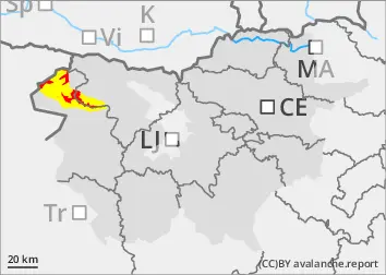
The current snowpack pattern is uncommon and requires special attention and caution!
Large amount of new snow, snowdrift accumulations and a weak layer in the old snow cover.
New fallen snow has put additional load on the weak layers in the old snow cover. Places with blown snow and shady areas where there is a weak layer deep in the snowpack are dangerous.
Snow will continue to fall during the day, with southerly winds blowing new fallen snow and building up larger snowdrift accumulations. Avalanches, possibly major, will occur spontaneously. In the current conditions, we advise against visiting the high alpine regions! In parts of the mid-mountains where it rains, wet snow avalanches and gliding avalanches may occur.
Snowpack
dp.1: deep persistent weak layer dp.4: cold following warm / warm following cold
Previous snowfalls have brought more snow on top of a weak snowpack. Snow will continue during the day, with the snow line mainly between 1100 m and 1400 m. This snow episode will bring 60-80 cm of New fallen snow to the high alpine regions by Thursday morning. South to south-easterly winds, which will strengthen during the day, will build up new drifts on the leeward sides of the ridges. Deep and persistent weak layers are present in the old snow cover. The snowpack is unstable.
Tendency
Some new fallen snow will fall in the coming days, but conditions will remain challenging.
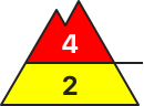
Danger level
treeline
Avalanche Problem
New snow
Treeline
Wind slab
Treeline
Persistent weak layer
Treeline
Wet snow
1400m
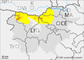
The current snowpack pattern is uncommon and requires special attention and caution!
New fallen snow, blowing snow and weak layers in the snowpack in the high alpine regions
New fallen snow has put additional load on the weak layers in the old snow cover. Places with blown snow and shady areas where there is a weak layer deep in the snowpack are dangerous.
Snow will continue to fall during the day, with southerly winds blowing new fallen snow and building up larger snowdrift accumulations. Spontaneous avalanches will occur. In the current conditions, we advise against visiting the high alpine regions! In parts of the mid-mountains where it is raining, wet snow avalanches and gliding avalanches may occur.
Snowpack
dp.1: deep persistent weak layer dp.4: cold following warm / warm following cold
Previous snowfalls have brought more snow on top of a weak snowpack. Snow will continue during the day, with the snow line mainly between 1100 m and 1400 m. During this snow episode, around 50 cm of New fallen snow will have fallen in the High alpine regions by Thursday morning. South to south-easterly winds, which will strengthen during the day, will build up new drifts on the leeward sides of the ridges. Deep and persistent weak layers are present in the old snow cover. The snowpack is unstable in many places.
Tendency
Some new fallen snow will fall in the coming days, but conditions will remain challenging.