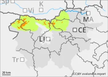
The current snowpack pattern is uncommon and requires special attention and caution!
New fallen snow has hidden old traps.
Even a small additional load can trigger a medium-sized avalanche near ridges and other typical leeward locations with blowing snow. Chain avalanches are also possible, where the triggering of a small clast of freshly blown snow causes the collapse of old Weak layers in the snowpack!
In some places, the additional load (blowing snow) will naturally trigger cluster avalanches.
Snowpack
dp.1: deep persistent weak layer dp.5: snowfall after a long period of cold
The old snow cover was thin and variable in places. In some places, a crust had formed on the surface, most of which bore the weight of sand. In the osoles, the snowpack was mostly dry, compacted and hard at the surface, and completely cut at depth. Ridges and peaks were in many places blown down to a crusted or icy base. Particularly near the ridges, areas of blown snow had formed, under which the snowpack was thinned.
Snow has been falling on such a surface above about 1000 m since Friday evening with a strong SW-SW wind. Up to 50 cm of new fallen snow has fallen, which has covered the old snow cover and has not bonded well with it. New snowdrift accumulations have formed, which naturally put additional stress on the old snowpack, which has persistent weak layers. Today, the fresh snowpack will become slightly thinner due to the influence of the sun, especially in the mid-mountains.
Tendency
Tuesday morning will be sunny, but as the SW wind strengthens, it will first turn cloudy on the coastal side of the Julian Alps and the Dinaric Mountains. Elsewhere, it will become cloudy by the evening, with showers on Wednesday night. The avalanche danger will remain unchanged until Wednesday.
Danger level
treeline
Avalanche Problem
Persistent weak layer
Treeline
Wind slab
Treeline
New fallen snow, slush
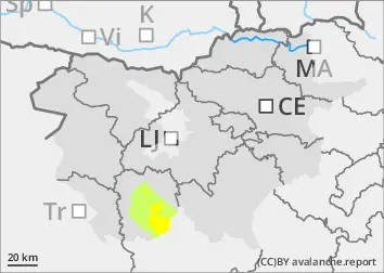
Snowpack stability is poor, especially in new snowdrift accumulations at typical locations - along ridges, in ravines, etc. Here, a small additional load can trigger a medium-sized avalanche.
Snowpack
dp.5: snowfall after a long period of cold
The old snow cover has been transformed - frosted in the washes, cut on the washes. In some places, there was a hard crust on the surface.
More than 100 litres of precipitation had fallen on such a surface since Friday night, most of it as snow above 1500 m. It is likely that more than 50 cm of snow fell. Where snow has fallen on hard, frozen ground, it has not bonded well with it. In the osoyas, the snow fell on a snowpack that was almost completely cut. It snowed with a strong SW-SE wind, especially near the ridges, which caused snowdrift accumulations. The snowpack is expected to thin out somewhat today.
Tendency
Tuesday morning will be sunny, with clouds starting in the morning. South-westerly winds will blow. Snow is likely on Wednesday. The avalanche danger will remain similar until Wednesday.
Danger level
1300m
Avalanche Problem
Wind slab
1300m
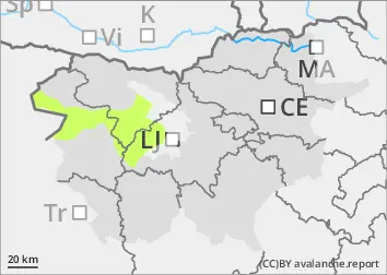
Even a small additional load can trigger a small avalanche, especially in typical leeward areas with freshly blown snow.
Snowpack
dp.5: snowfall after a long period of cold
Up to 40 cm of new fallen snow has fallen on bare ground above 1300 m since Friday. Snowdrift accumulations have formed due to the strong SW wind.
If the weather is sunny, the snowpack will clear.
Tendency
Tuesday morning will be sunny, but as the SW wind strengthens, it will first turn cloudy on the coastal side of the Julian Alps and the Dinaric Mountains. Elsewhere, it will become cloudy by the evening, with showers on Wednesday night. The avalanche danger will remain unchanged until Wednesday.