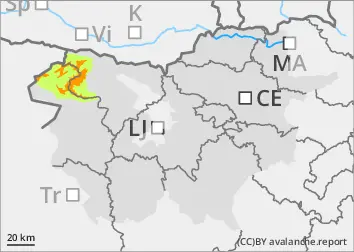
The current snowpack pattern is uncommon and requires special attention and caution!
New fallen snow will hide old traps and the danger of avalanches is increasing.
Even a small additional load can trigger a medium-sized avalanche near ridges and other typical leeward locations with blowing snow. Chain avalanches are also possible, where the triggering of a small clast of freshly blown snow causes the collapse of old Weak layers in the snowpack!
In some places, the additional load (blowing snow) will naturally trigger cluster avalanches.
Snowpack
dp.1: deep persistent weak layer dp.5: snowfall after a long period of cold
Snow is scarce and local conditions are quite variable. A crust has formed on the surface in some places, which in many places also bears the weight of sand. In the osoles, the snowpack is mostly dry, compacted and hard on the surface, and completely cut at depth. Ridges and peaks are in many places blown down to a crusted or icy base. Particularly near the ridges, areas of blown snow have formed, under which the snowpack is thinned.
Snow has been falling on such a surface above about 1000 m since Friday evening with a strong SW wind. New fallen snow will hide the old snowpack and will have little connection with it. New snowdrift accumulations are forming, which naturally put additional stress on the old snow cover, which has deep, persistent weak layers.
Tendency
Rainfall will continue into the night on Monday, easing on Monday morning. Up to 20 cm of snow may still fall. Clouds will break, clearing in the middle of the day. Winds will weaken. Tuesday will be mostly sunny. The danger of avalanches will remain significant.
Danger level
treeline
Avalanche Problem
Persistent weak layer
Treeline
Wind slab
Treeline
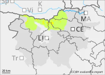
New fallen snow will hide old traps and the danger of avalanches is increasing.
Even a small additional load can trigger a small avalanche near ridges and other typical leeward areas with blowing snow. Chain avalanche triggering is also possible, where the triggering of a small clast of freshly blown snow causes the collapse of old weak layers in the snowpack!
In particular, in some places, the additional load (blowing snow) will naturally trigger cluster avalanches.
Snowpack
dp.1: deep persistent weak layer dp.5: snowfall after a long period of cold
Snow is scarce and local conditions are quite variable. A crust has formed on the surface in some places, which in many places also bears the weight of sand. In the osoles, the snowpack is mostly dry, compacted and hard on the surface, and completely cut at depth. Ridges and peaks are in many places blown down to a crusted or icy base. Particularly near the ridges, areas of blown snow have formed, under which the snowpack is thinned.
On such a surface above about 1000 m it has been snowing lightly since Friday evening with an increasing SW wind. New fallen snow will hide the old snow cover and will have little connection with it. New snowdrift accumulations are forming, which naturally put additional stress on the old snow cover, which has deep, persistent weak layers.
Tendency
Rainfall will continue into the night on Monday, easing on Monday morning. Up to 20 cm of snow may still fall. Clouds will break, clearing in the middle of the day. Winds will weaken. Tuesday will be mostly sunny. The danger of avalanches will remain significant.
Danger level
1200m
Avalanche Problem
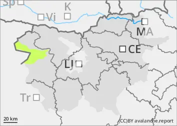
Wind slab
1200m
Even a small additional load can trigger a small avalanche, especially in typical leeward areas with freshly blown snow.
Snowpack
dp.5: snowfall after a long period of cold
20-30 cm of New fallen snow will fall on bare ground above 1200 m by Saturday evening. Snowdrift accumulations are forming due to the strengthening SW wind.
Tendency
Rainfall will continue into the night on Monday, easing on Monday morning. Up to 20 cm of snow may still fall. Clouds will break, clearing in the middle of the day. Winds will weaken. Tuesday will be mostly sunny.