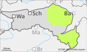
The avalanche danger is low. Very occasional small, wet gullies on embankments or in gullies and bowls are still possible.
Snowpack
Due to the mild temperatures, the snow cover, snowpack is damp to wet. Overnight, a melt-freeze crust forms in windless areas, which thaws again during the day with sunlight. In general, the snow cover is well below average.
Tendency
The avalanche risk remains low.
On Friday and at the weekend, winds from the south-east will push low, high fog-like clouds into the Alpine foothills, while the higher mountains will remain clear with a southerly flow. It will cool down slightly.
Danger level
Avalanche Problem
Wet snow
Low avalanche danger, isolated wet snow slides in steep gullies and bowls.
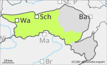
The avalanche danger is low. Small wet snow slides can still occur in steep gullies and bowls in western, southern and eastern aspects. Wet slides from wooded areas or embankments are also possible at low altitudes. In extremely steep, north-facing gullies above the tree line, small slab avalanches in persistent weak layers can be triggered by small additional loads.
Snowpack
The persistent weak layer problem is easing due to the warming. However, the snow cover, snowpack has become unstable due to the increasing moisture, especially in western, southern and eastern aspects. During the clear night, the firmness of the snow cover increases, during the day the stability, snowpack stability decreases again.
Tendency
The avalanche risk remains low.
On Friday and at the weekend, winds from the south-east will push low, high fog-like clouds into the Alpine foothills, while the higher mountains will remain clear with a southerly flow. It will cool down slightly.