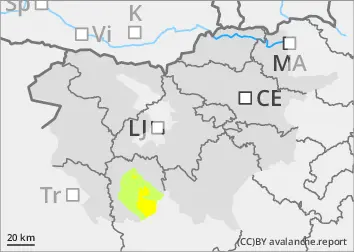
The new light snow has not adhered well to the old snow base. In moderate to strong north-easterly winds, slush is forming. Especially above the forest line in the Snežnik area, a snow avalanche is possible even at low loads. Spontaneous avalanches are also possible.
Snowpack
dp.6: cold, loose snow and wind
When it snows, the snowpack slowly increases. Up to 10 cm of light, dry snow has fallen on hard ground above about 1300 m. At the same time, moderate to strong winds are blowing, carrying the snow and building drifts and drifts. The snowpack is markedly uneven. There is a lot of blowing snow, especially on the leeward slopes.
Tendency
Snow and strong winds will continue. A total of 20-40 cm of snow will fall by Wednesday morning, with the highest snowfall in the Snežnik area.
Danger level
Avalanche Problem
Wind slab
More amount of new snow with wind.
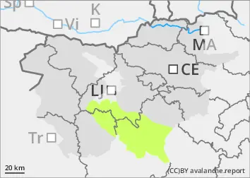
The new light snow has not adhered well to the old snow base. In moderate to strong north-easterly winds, slush is forming.
Snowpack
dp.6: cold, loose snow and wind
When it snows, the snowpack slowly increases. Up to 10 cm of light, dry snow falls. At the same time, a moderate wind is blowing, which carries the snow and builds drifts and drifts. The snowpack is markedly uneven. There is a lot of blowing snow, especially on the leeward slopes.
Tendency
Snow and wind will continue. A total of 20 to 30 cm of snow will have fallen by Wednesday morning.
Danger level
2000m
Avalanche Problem
Persistent weak layer
2000m
Wind slab
Treeline
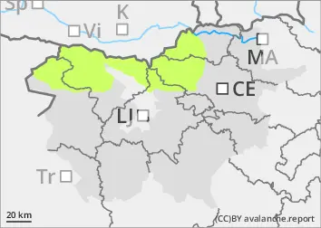
The danger of avalanches is low.
The snowpack is mostly stable. In some places in the high alpine regions, especially on fresh drifts of blown snow, a small, clustered avalanche can be triggered under higher loads.
Snowpack
dp.4: cold following warm / warm following cold
There is little snow, and the peaks and ridges are in some places blown bare. In the high alpine regions, weak layers may be present in the old snow cover. In some places, Crust has formed in recent days. The cold weather has not changed the situation much.
Tendency
Light to moderate snow until Wednesday morning. 5 to 20 cm of light and sometimes fluffy snow is expected, with the least in the western Julian Mountains and the western Karavanke Mountains. Wind will carry snow to exposed positions. The risk of triggering will increase slightly as the snow will fall on hard and in some places icy ground. As snow will be relatively scarce, only minor avalanches of dry snow will be possible.