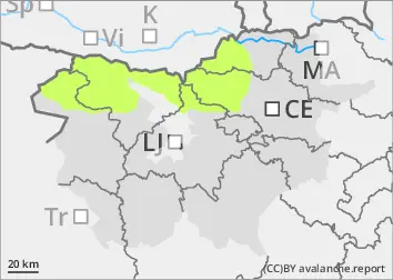
Danger level
 | 2000m |
|  |
|  |

![]()
The danger of avalanches is low.
The snowpack is mostly stable. In arid areas above the snow line, weak layers may be present in the snowpack. In a few places in the high alpine regions, a small, clustered Avalanche may be triggered under higher loads.
Snowpack
dp.4: cold following warm / warm following cold
Snow is scarce. There is a crust on top, which has been building up over the last few days. There is some new snow on the old snow base at an altitude of 2000 m above sea level. Peaks and ridges may be blown. On the sunny slope, there are already significant areas of land outside the High alpine regions. In the high alpine regions, weak layers may be present in the old snowpack.
Tendency
Tuesday will be cloudy and foggy, with parts of the high alpine regions above the low cloud line. Wednesday will be cloudy and foggy with light snow. Around 10 cm of New fallen snow can be expected.